On this page
- Before the tall tree: the Ohlone
- El Palo Alto and the Portolá expedition
- Missions and ranchos
- Mayfield, the railroad and a town of saloons
- The Stanfords and their university
- University Park becomes Palo Alto
- Professorville and the first tech boom
- Two towns become one
- The garage and the research park
- Postwar growth, Eichlers and open space
- From PARC to the dot-com era
- Palo Alto today
- Palo Alto timeline
- Where to see history in person
- FAQ
Every city has an origin story. Palo Alto has several of them stacked on top of each other like rings in a tree. There is the story of the Ohlone people who fished and gathered along San Francisquito Creek for thousands of years. There is the story of a Spanish expedition that camped beneath a towering redwood in 1769. There is the story of a grieving railroad tycoon who built a university on his horse farm. There is also the story most visitors already know, the one about two young engineers and a rented garage.
This guide walks through all of them in order. Along the way you will find the places where history still shows, from a thousand-year-old tree to a shingled cottage on Addison Avenue. If you only have a few minutes, skip to the timeline near the end.
Before the tall tree: the Ohlone
Long before anyone called this place Palo Alto, it was home to Ohlone people. The group that lived in this part of the Peninsula is often called the Puichon. Their villages sat near the creeks that run from the foothills to the bay. San Francisquito Creek was one of the most important. It gave fresh water, fish and shade. The marshes along the bay supplied shellfish, waterfowl and tule reeds for boats and houses.
The Ohlone managed the land with care. They used controlled burns to keep grasslands open and to encourage the plants they relied on. Acorns from the valley oaks and coast live oaks were a staple food. They were gathered in the fall, then dried and ground and leached to make them edible. Shell mounds near the bay shore marked centuries of village life.
Spanish colonization devastated these communities. Disease, forced labor at the missions and the loss of land caused a dramatic collapse in population within a few decades. Ohlone people did not disappear, though. Their descendants still live in the Bay Area today. Many are working to restore language, ceremony and a public understanding of the region's first history.
El Palo Alto and the Portolá expedition
In the fall of 1769 a Spanish expedition led by Gaspar de Portolá marched north from San Diego. The goal was to find Monterey Bay. They overshot it. Scouts instead became the first Europeans on record to see San Francisco Bay. Soon after, the party turned south and made camp beside San Francisquito Creek from November 6 to November 11.
Near their camp stood a pair of coast redwoods so tall that they could be seen from miles away across the flat valley. The explorers called it El Palo Alto, which translates roughly as "the tall stick." Historians still debate whether the expedition camped under this exact tree or one a little downstream. What matters is that the name stuck. It was later used for a rancho, a horse farm and a town.
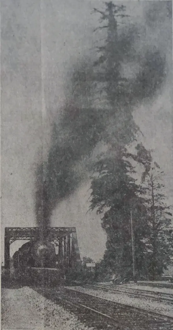
El Palo Alto is still alive. One of its two trunks fell in the late 1800s and the survivor has lost dozens of feet of height since then. In the nineteenth century it stood around 162 feet tall. Today it measures about 110 feet. Its age is estimated at roughly 1,080 years, which means it was already centuries old when Portolá arrived.
The tree has had plenty of help. Leland Stanford built a wooden bulkhead to protect the creek bank. Jane Stanford later paid for a concrete wall. A plaque went up in 1926 and a watering system followed in 1955. For more than a century the tree breathed smoke from passing steam and diesel trains. When Caltrain switched to electric service in 2024, that stress finally ended. You can visit it in tiny El Palo Alto Park at the corner of Alma Street and Palo Alto Avenue.

Missions and ranchos
After Portolá came the missions. Father Junípero Serra founded Mission Santa Clara de Asís in 1777. Its vast grazing lands stretched across most of what is now Palo Alto. Cattle and sheep replaced Ohlone hunting grounds.
When Mexico won independence from Spain in 1821, the mission system broke apart. Former mission lands were granted to private owners as ranchos. In 1841 Rancho Rinconada del Arroyo de San Francisquito went to María Antonia Mesa. It covered parts of today's northern Palo Alto and Menlo Park. To the south, Rancho Rincón de San Francisquito was bought in 1847 (some sources say 1849) by the brothers Secundino and Teodoro Robles. Their land covered a huge share of modern Palo Alto and Stanford.
The Robles family lived well for a time, but American courts and legal costs whittled their holdings down. In 1863 their claim was reduced to 6,981 acres. Bit by bit the land was sold off. The family's adobe hacienda was finally ruined by the 1906 earthquake.
Mayfield, the railroad and a town of saloons
California became part of the United States in 1848. Settlers poured in after the gold rush and a small town called Mayfield grew up in the 1850s around a stagecoach stop near El Camino Real. Today you would find it around California Avenue.
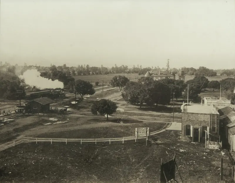
The railroad reached Mayfield in October 1863. A few months later trains ran all the way to San Jose. Mayfield prospered as a farm town with a lively main street. It had stores, hotels and more saloons than it strictly needed. By the 1880s it counted thirteen of them.
Those saloons would change the course of local history. When Leland Stanford began planning a university next door, he wanted a sober town at its gates. Mayfield would not give up its bars. So Stanford and his allies turned elsewhere and backed a brand new town to the north. Mayfield finally banned saloons in 1905. By then it was too late.
The Stanfords and their university
Leland Stanford was one of the most powerful men in California. He had made a fortune as one of the Big Four behind the Central Pacific Railroad. He also served as governor and later as a United States senator. In 1876 he began buying land along San Francisquito Creek for a horse farm. He called it the Palo Alto Stock Farm, after the famous tree.
The farm became a laboratory of its own. In 1878 the photographer Eadweard Muybridge set up a row of cameras on the track there. His sequence of a galloping horse proved that all four hooves leave the ground at once. Those images are a key step toward motion pictures. Students still call Stanford "the Farm" today.
Tragedy changed everything. In 1884 the Stanfords' only child, Leland Stanford Jr., died of typhoid fever in Italy at age 15. His grieving parents decided that "the children of California shall be our children." In 1885 they founded Leland Stanford Junior University on the stock farm. It opened to students on October 1, 1891. Tuition was free in those early years.
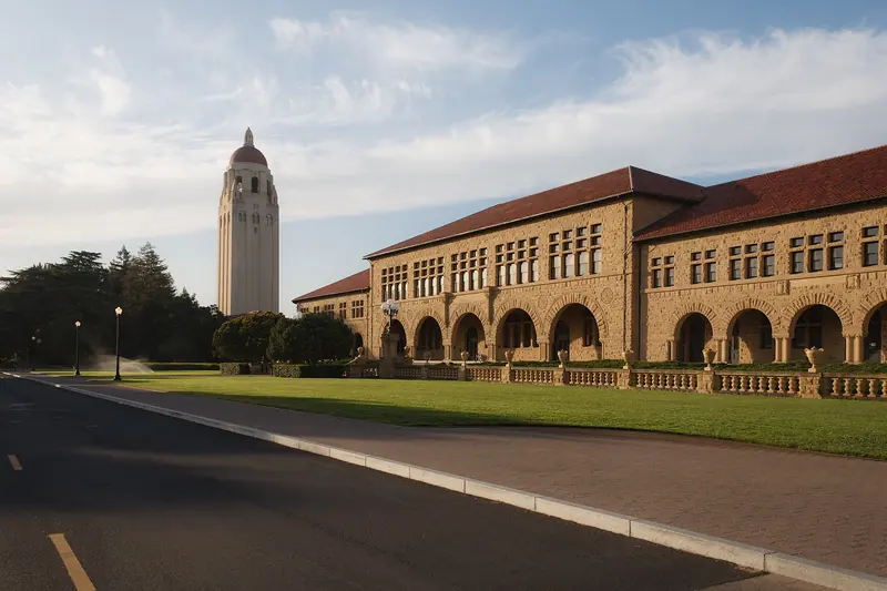
The campus followed a plan by landscape architect Frederick Law Olmsted. The sandstone Main Quad with its red tile roofs and arcades still anchors it. Memorial Church, finished in 1903, honors Leland Stanford himself, who died in 1893. The 1906 earthquake did heavy damage across campus, including the church's original tower. Much of what you see today was rebuilt after it.

University Park becomes Palo Alto
With a university on the way, someone had to build a town for its faculty and staff. That job fell to Timothy Hopkins, an heir to the fortune of railroad partner Mark Hopkins and a close friend of the Stanfords. In 1887 he bought roughly 700 acres north of campus and laid out a tidy grid of streets. He called it University Park.
Every deed came with a rule that alcohol could not be made or sold on the property. The idea was to keep students sober and the new town respectable. Streets were named after writers, scientists and poets, which is why you still walk down Emerson, Bryant, Waverley, Kipling and Tennyson. University Avenue linked the train station directly to the Stanford entrance.
The town grew fast. The young town soon took the old name of Palo Alto. On April 16, 1894, Palo Alto officially incorporated as a city. A charter followed in 1909. In 1950 the city moved to the council and city manager system it still uses today.
Early Palo Altans were proud of their civic spirit. The city built its own utilities early: water in 1896, sewers in 1898, electricity in 1900 and gas in 1917. Residents planted thousands of street trees. The result is the shady canopy that still makes downtown streets feel cool on hot days.

Professorville and the first tech boom
Many of Stanford's first professors built homes a few blocks south of University Avenue. Their shingled houses and Craftsman bungalows gave the area its nickname, Professorville. The neighborhood is now a National Register historic district. It is one of the nicest walks in town, especially in the late afternoon light.
Palo Alto's first technology boom started here too. In 1909 Cyril Elwell founded the Federal Telegraph Company in Palo Alto. Two years later the inventor Lee de Forest joined the company. Between 1911 and 1913 he developed the first vacuum tube amplifier and oscillator at its lab near the corner of Channing Avenue and Emerson Street. A state landmark plaque marks the spot. Those inventions helped make radio, television and the whole electronics age possible.
Two towns become one
For decades Palo Alto and Mayfield sat side by side. Palo Alto was the dry, polished university town. Mayfield was the older farm town with a rougher reputation. Over time the gap narrowed. Mayfield's saloons were gone and its economy leaned more and more on its larger neighbor.
In 1925 Mayfield voters approved annexation to Palo Alto. The two were formally joined that July. Mayfield's main street became what we now call California Avenue. A large cannery operated there from 1918 until 1949. At its peak it was the biggest employer in town and it processed fruit and vegetables from the orchards that once filled the Santa Clara Valley.
The garage and the research park
In the 1930s Stanford engineering professor Frederick Terman noticed a problem. His best students kept leaving for jobs back East. He encouraged them to start companies near campus instead. Two of them, Bill Hewlett and Dave Packard, took his advice.
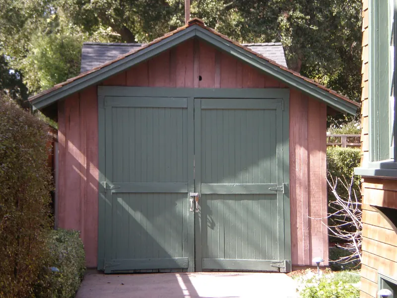
In 1938 Packard and his wife Lucile rented the downstairs of a house at 367 Addison Avenue. Out back was a small wooden garage. Hewlett moved into a shed on the property. On January 1, 1939, the two friends made their partnership official. Their first product was an audio oscillator. One of their early customers was Walt Disney Studios, which used the instruments while making the film Fantasia.
In 1987 the state of California registered the garage as California Historical Landmark No. 976, the Birthplace of Silicon Valley. The plaque was dedicated in 1989. HP later bought the property and restored it. It is private property and not open to the public. You can still see the garage from the sidewalk.
After World War II Stanford looked for a way to earn money from its huge land holdings without selling them. In 1951 it created the Stanford Industrial Park on land along Page Mill Road. Varian Associates was among the first tenants. Hewlett-Packard followed. The idea of a tech campus next to a research university was new at the time. Today the renamed Stanford Research Park is home to well over a hundred companies.

Postwar growth, Eichlers and open space
The years after the war brought a flood of new residents. Orchards gave way to subdivisions in the southern half of the city. The developer Joseph Eichler built close to 3,000 homes in Palo Alto. His modern houses had glass walls, open floor plans and atriums that brought the garden inside. Eichler was also notable for selling to buyers regardless of race at a time when many developers refused.
That matters because much of the region was shaped by racial covenants, redlining and blockbusting. Those practices pushed many Black families toward East Palo Alto, a separate community across the county line. The legacy of those decisions still shapes housing debates in Palo Alto today.
Palo Alto also grew outward. It annexed land in the foothills and along the bay. In 1965 the city opened Foothills Park in the hills above town. For decades it was open only to residents and their guests. After a lawsuit and a long community debate, the park opened to everyone in the early 2020s and has since been renamed Foothills Nature Preserve. On the other side of town the city protected a large stretch of marsh now known as the Baylands Nature Preserve.
From PARC to the dot-com era
In 1970 Xerox opened the Palo Alto Research Center, known as PARC. Its researchers produced a startling list of inventions. They built the Alto, an early personal computer named after the city. They helped create the graphical user interface, the laser printer and Ethernet networking. A young Steve Jobs visited in 1979 and came away convinced that the mouse and the windowed desktop were the future.
Jobs later lived in Palo Alto with his family for many years. By the 1990s downtown Palo Alto had become shorthand for startup culture. A modest office at 165 University Avenue earned the nickname "the lucky building" after early versions of Google and PayPal worked there. Facebook moved to Palo Alto in 2004 and grew up in downtown offices before eventually relocating. Countless smaller companies followed the same path from a coffee shop table to a sublet office on University Avenue.
Tesla made its headquarters on Deer Creek Road in Stanford Research Park for years. It moved its corporate headquarters to Texas in 2021. Two years later it announced a global engineering headquarters back in Palo Alto on HP's former campus. The pattern repeats. Companies come and go but the ideas keep flowing through this small city.
Palo Alto today
About 68,000 people lived in Palo Alto at the 2020 census. More than 80 percent of adults hold a bachelor's degree and over a third of residents were born outside the United States. Home prices are among the highest in the country. The city still runs its own utilities and still loves its trees. It also argues passionately about housing, traffic and what kind of place it wants to be next.
For visitors, history is easy to find. Stand under El Palo Alto at the north end of town. Walk the streets of Professorville and pause at 367 Addison Avenue. Read the landmark plaque at Channing and Emerson. Then ride Caltrain one stop to California Avenue, which was once the main street of Mayfield. Grab lunch in what was once a saloon town.
Palo Alto timeline
- Before 1769: Ohlone communities live along San Francisquito Creek and the bay shore.
- 1769: The Portolá expedition camps near El Palo Alto from November 6 to 11.
- 1777: Mission Santa Clara de Asís is founded. Its lands include today's Palo Alto.
- 1841: Rancho Rinconada del Arroyo de San Francisquito is granted to María Antonia Mesa.
- 1847: The Robles brothers buy Rancho Rincón de San Francisquito (some sources say 1849).
- 1855: Mayfield forms around a stagecoach stop.
- 1863: The railroad reaches Mayfield.
- 1876: Leland Stanford starts buying land for the Palo Alto Stock Farm.
- 1878: Eadweard Muybridge photographs a galloping horse on the farm.
- 1885: The Stanfords found their university. It opens in 1891.
- 1887: Timothy Hopkins lays out University Park.
- 1894: Palo Alto incorporates on April 16.
- 1909: Federal Telegraph Company is founded in Palo Alto.
- 1925: Mayfield is annexed to Palo Alto.
- 1939: Hewlett-Packard is founded in the Addison Avenue garage.
- 1951: Stanford Industrial Park opens.
- 1965: Foothills Park opens.
- 1970: Xerox PARC opens.
- 1999: Google moves into 165 University Avenue.
- 2004: Facebook moves to Palo Alto.
- 2024: Electric Caltrain service begins.
Where to see history in person
You can cover the highlights in a single relaxed day without a car. Start at El Palo Alto Park near the Palo Alto Caltrain station. Walk south through downtown on Ramona Street to see Spanish Revival storefronts from the 1920s and 1930s. Continue into Professorville and stop at 367 Addison Avenue. From there it is a short walk to the Federal Telegraph plaque at Channing and Emerson.
In the afternoon, cross into Stanford. Walk Palm Drive to the Main Quad and step inside Memorial Church. Visit the Cantor Arts Center to see works the Stanford family collected. If you have energy left and the observation deck is open (it is closed for renovation until late January 2027), ride the elevator up Hoover Tower for a view over everything you just walked through. Many visitors pair the day with a Silicon Valley tour that starts in San Francisco. Others download a self-guided audio walk and go at their own pace.
In this section
Frequently asked questions
Why is it called Palo Alto?
The city is named after El Palo Alto, a coast redwood beside San Francisquito Creek. Spanish explorers with the Portolá expedition camped near it in 1769 and the name means tall stick or tall tree in Spanish.
When was Palo Alto founded?
Timothy Hopkins laid out the townsite of University Park in 1887 to serve the new Stanford University. The town incorporated as Palo Alto on April 16, 1894. It absorbed the neighboring town of Mayfield in 1925.
How old is the El Palo Alto tree?
Arborists estimate that El Palo Alto is roughly 1,080 years old. It still stands beside the Caltrain tracks at the northern edge of the city in El Palo Alto Park.
Why is Palo Alto called the birthplace of Silicon Valley?
Hewlett-Packard was founded in a garage at 367 Addison Avenue in 1939. The state of California named that garage the Birthplace of Silicon Valley. Stanford Research Park, Xerox PARC and many famous startups followed nearby.