On this page
Palo Alto is young, but it has already lost a surprising amount. Its first great losses came in a single minute in 1906. Later ones came more slowly: a library cleared for a new City Hall, bohemian cottages bulldozed for new houses, a motel tower that once hosted a Nobel toast, a bowling alley that teenagers still mention. Some places vanished completely. Others survive as a plaque, a stump or a name.
This page gathers the documented losses in date order, each with the year it went and the source behind it. It focuses on buildings and public places, not the many small businesses that come and go every year. For what still stands, see our guide to historic landmarks.
1906: the earthquake losses
The earthquake of April 18, 1906 hit Stanford hardest. Memorial Church lost its spire and its front. The new gymnasium and the new library, both nearly finished, were wrecked. The Memorial Arch at the entrance to the Main Quad was damaged so badly that it had to come down. The church was taken apart and rebuilt between 1908 and 1917, but the spire was never replaced. You can still find the stumps of the Memorial Arch.
Downtown lost buildings too. F. C. Thiele's new $30,000 store on University Avenue collapsed. The Simkins Building lost its ground-floor walls and leaned about three feet. Fraternal Hall at 140 University Avenue lost its cornice and part of an upper wall but survived and is now on the National Register. Our 1906 earthquake page has the full account.
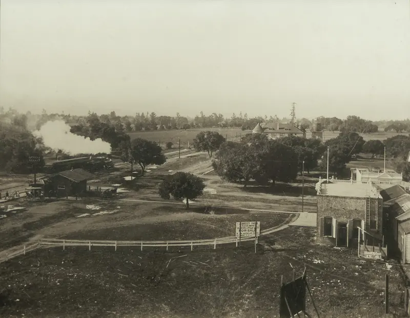

The early town's lost places
- The Circle and its flagpole. An open space near the station known as the Circle served as the town's gathering place. A 205-foot flagpole was dedicated there in 1908 by the Native Sons of the Golden West and later moved to the Hostess House site, according to a 1969 city marker. The open Circle is long gone, though a short street near the station is still called University Circle.
- The University Avenue arch. From 1911 to 1925 an electric arch lit up University Avenue.
- The old depots. The first station was a simple shelter built for an auction of town lots. A larger arched depot replaced it. The Palo Alto Times complained for years about its condition until Southern Pacific opened today's Streamline Moderne depot in 1941.
The streetcars, 1925 to 1934
Palo Alto once had streetcars. Local service inside the city ended on September 27, 1925. The line to Stanford ran its last day on October 21, 1929. Interurban runs through Palo Alto ended on September 30 and October 1, 1934. No tracks remain on the streets. Our streetcars page traces the old routes.
Mid-century losses
The Barron Mansion, 1936
Edward Barron's country house, the building that gave Barron Park its name, burned down in 1936. The neighborhood kept the name.
The Mayfield cannery, 1949
Thomas Foon Chew's Bayside Canning Company began operating on Portage Avenue in 1918 and the cannery closed in 1949. The building was not lost. It later housed Fry's Electronics and reopened in 2026 as an all-electric office building with a mosaic honoring Chew. See our Thomas Foon Chew page.
Perry Lane, 1963
The cottages on Perry Lane, a small enclave near Stanford, were home to writers and bohemians in the late 1950s, Ken Kesey among them. They were demolished in August 1963. Today's Perry Avenue occupies the site. Our Perry Lane page tells the story.
Oregon Avenue, early 1960s
After voters narrowly approved Oregon Expressway on June 5, 1962, Oregon Avenue was widened into the new road. More than 90 homes on the south side of the avenue were moved or torn down and the expressway was in use by about 1964. Our freeways and expressways history covers the fight.
The Carnegie library, 1967
Palo Alto's first library building opened in 1904 with help from a $10,000 Carnegie grant. It was expanded twice, then demolished in 1967 to make room for the current City Hall at 250 Hamilton Avenue, completed in 1970. See our City Hall and King Plaza page.
The 1970s to the 1990s
- Cubberley High School, 1979. The third Palo Alto high school opened on Middlefield Road in 1956 and closed in June 1979 after a 3 to 2 board vote and a bitter fight. The campus became Cubberley Community Center.
- The Mayfield grammar school, 1982. Built in 1923 in the Spanish Colonial style, it served as an elementary school until 1966 and housed other programs until it was torn down in 1982. A panel at the Page Mill Road playing fields recalls it.
- The Harvey gum factory, 1982. A chewing gum factory near the airport was torn down the same year.
- The Festival Cinema, 1985. A 114-seat revival house at 475 Hamilton Avenue, opened in 1972 as the Academy Cinema, closed on April 18, 1985.
- Woolworth's, 1989. The store at 352 University Avenue, opened in 1949 with a lunch counter and the longest frontage on the street, made its last sale in 1989.
- The Varsity Theatre, 1994. The 1927 movie house at 456 University Avenue closed as a cinema in 1994. The building survives in other uses. Our downtown theaters page covers it.
- Prewar houses, 1996. That year new owners bulldozed 34 houses built before 1940, prompting an emergency demolition moratorium, as the Palo Alto Weekly reported.

The 2000s to today
Rickey's, 2006
Restaurateur John Rickey opened Rickey's Studio Inn at 4219 El Camino Real in 1954 with one-story redwood buildings around lawns and pools. He added a high-rise wing in 1956 and 1957. In December 1956 William Shockley's team toasted his Nobel Prize there. The property later operated as Hyatt Rickey's. It was torn down and a 181-unit housing development broke ground on the site in January 2006. Our El Camino Real history covers the motel era.
The Juana Briones house, 2011
The foothill house associated with Juana Briones de Miranda, one of the most remarkable figures of Mexican California, was demolished in June 2011 after a long legal fight between its owners and preservationists. The site remains California Historical Landmark No. 524, with a state plaque placed on March 12, 2007. Read more on our Juana Briones page.
Palo Alto Bowl, 2011
The bowling alley at 4329 El Camino Real closed in September 2011. Palo Alto has had no bowling alley since. Residents still mention it as a loss for local teenagers.
More recent closings
- Fire Station 3, 2018. Crews demolished the 1948 station at 799 Embarcadero Road on January 30, 2018.
- Village Cheese House, 2019. The Town & Country Village sandwich counter closed in 2019 after 60 years.
- CinéArts at Palo Alto Square, 2020. The two-screen theater at El Camino Real and Page Mill Road closed in March 2020.
- University Art, 2026. The art supply store, in Palo Alto since 1948, closed in 2026 after 78 years.
Finding the traces
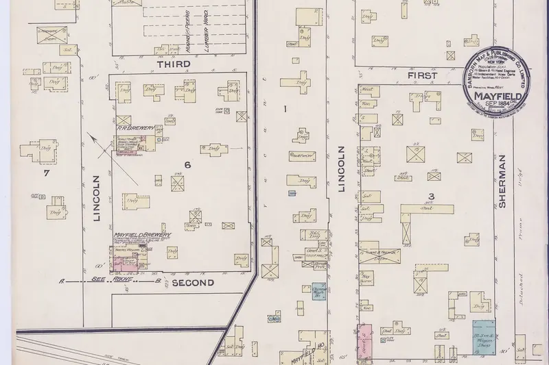
A few losses left something to see. Look for the Memorial Arch stumps at Stanford, the Juana Briones plaque on Old Adobe Road, the Mayfield panels in the playing fields parking lot at Page Mill Road and El Camino Real and the Chew mosaic at 340 Portage Avenue. The old town of Mayfield is covered on our Mayfield page. For a guided look at what remains of early Silicon Valley, a Bay Area history tour is the easiest option.
Frequently asked questions
What was on the site of Palo Alto City Hall before 1970?
The city's 1904 Carnegie library stood on the Hamilton Avenue site. It was expanded twice and then demolished in 1967 to make room for the current City Hall, which Edward Durell Stone and Associates designed and which was completed in 1970.
What happened to the Juana Briones house?
The house in the Palo Alto foothills, associated with the Californio landowner Juana Briones, was demolished in June 2011 after a long legal fight between its owners and preservationists. The site is California Historical Landmark No. 524 and a state plaque placed in 2007 still marks it.
Is Perry Lane still there?
No. The cottages on Perry Lane near Stanford, where Ken Kesey lived from about 1959, were torn down in August 1963. Today's Perry Avenue occupies the site and none of the original houses survive.
Does Palo Alto have a bowling alley?
Not since Palo Alto Bowl at 4329 El Camino Real closed in September 2011. The nearest lanes are in neighboring cities.
Why doesn't Stanford Memorial Church have a spire?
The 1906 earthquake brought the church's spire and clock tower down through the roof. The church was rebuilt between 1908 and 1917 without the spire. The quake also wrecked Stanford's new gymnasium and library and the Memorial Arch had to be taken down.