Nearby towns

Towns near Palo Alto

Palo Alto sits in a ring of small cities and hill towns that each feel different. Here is how they compare, how far they are and which ones you can reach without a car.

On this page
  1. The big picture: two counties and a creek
  2. The towns compared
  3. How the towns differ
  4. Getting between the towns
  5. Which town fits which trip
  6. Living in a neighboring town
  7. FAQ

Palo Alto gets the attention, but it is only one piece of a patchwork. Within about ten miles you cross two counties and nine separate cities and towns, each with its own city hall, its own rules and its own feel. Some are dense and busy, with train stations and long restaurant rows. Others have no shops at all, by design. A few are mostly forest and horse trails.

This section covers the neighbors that matter most to visitors and to people thinking about moving here. Each town guide explains where the place is, its history, what to see, how to get there and what daily life is like. This hub helps you tell them apart. Population figures come from the 2020 census, which every town uses as its official count.

The big picture: two counties and a creek

San Francisquito Creek runs from the foothills to the bay along Palo Alto's northern edge. For most of its length it is also the line between Santa Clara County to the south and San Mateo County to the north. That line matters more than you might expect. It decides which bus system serves a street, which county parks are nearby and which sheriff or court handles local matters.

  • Santa Clara County side: Palo Alto, Mountain View, Los Altos and Los Altos Hills. Buses are run by VTA.
  • San Mateo County side: Menlo Park, East Palo Alto, Atherton, Woodside, Portola Valley and Redwood City. Buses are run by SamTrans.

The landscape splits the other way, from east to west. Near the bay you find flat ground, freeways and the Bay Trail. In the middle runs El Camino Real with the Caltrain line beside it. That is where the downtowns cluster. West of Interstate 280 the land rises into oak hills and redwood canyons. The towns there are rural on purpose.

The towns compared

Distances are rough driving distances from downtown Palo Alto. Traffic at rush hour can double the times you would expect.

TownCountyIncorporatedPopulation (2020)From Palo AltoCaltrainCharacter
Menlo ParkSan Mateo192733,780Next door, northYesWalkable downtown, venture capital, Meta
East Palo AltoSan Mateo198330,034Next door, northeastNoDiverse, bayfront trails, IKEA
Mountain ViewSanta Clara190282,376Next door, south and eastYes, two stationsCastro Street, Shoreline, Google
Los AltosSanta Clara195231,625Next door, southNoVillage downtown, quiet streets
Los Altos HillsSanta Clara19568,489Next door, southwestNoRural, no commerce, pathways
Portola ValleySan Mateo19644,456About 15 minutes westNoWooded, trails, Windy Hill
Woodside and AthertonSan Mateo1956 and 19235,309 and 7,18810 to 20 minutes northNoEstates, horses, Filoli
Redwood CitySan Mateo186784,292About 15 to 20 minutes northYesCounty seat, theaters, port

Incorporation years come from each town's official website or the state's list of cities. Redwood City is the oldest city in San Mateo County. East Palo Alto is the youngest city in this group by far.

Advertisement

How the towns differ

The Caltrain cities

Menlo Park, Mountain View and Redwood City have proper downtowns on or near the train line. Each has a main street lined with restaurants, a civic center and a mix of apartments and single-family homes. They are the easiest neighbors to visit without a car and the most likely to have a hotel room when Palo Alto is full. Mountain View and Redwood City are each larger than Palo Alto by population.

The quiet residential cities

Los Altos and Atherton are almost entirely residential. Los Altos keeps its shops in a compact village downtown and a few small districts along El Camino Real and Foothill Expressway. Atherton has no commercial zoning at all, so its streets are almost entirely homes, private schools and a single town park. Both are known for large lots and very expensive homes.

The hill towns

Los Altos Hills, Portola Valley and Woodside sit in the foothills of the Santa Cruz Mountains. They were incorporated in the 1950s and 1960s by residents who wanted to keep the hills rural. Minimum lot sizes are large, roads are narrow and winding and horse trails are common. For visitors their appeal is the outdoors: open space preserves, county parks and some of the best road cycling in the Bay Area.

East Palo Alto

East Palo Alto stands apart. It is a working-class and middle-class city with a large Latino community, a long Black history and a Pacific Islander community. It has its own city government, schools and civic life, plus some of the best bay shoreline access on this side of the bay at Cooley Landing and the Ravenswood preserve. Its history is tied closely to Palo Alto's, sometimes painfully. Our guide covers it in detail.

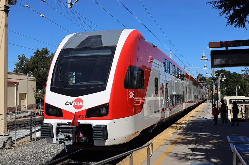
Electric Caltrain train at the Palo Alto station platform
Electric Caltrain trains link Palo Alto with Menlo Park, Redwood City and Mountain View in a few minutes each. Photo: San Mateo County Transit District, Wikimedia Commons, Public domain

Getting between the towns

By train

Caltrain is the backbone. Heading north from Palo Alto, the next stations are Menlo Park and then Redwood City. Heading south, the line stops at California Avenue, San Antonio and Mountain View. Not every train stops at every station, so check the Caltrain timetable before you plan around a particular stop. Our guide to riding Caltrain covers fares, Clipper and tap-to-pay.

By bus

The Palo Alto Transit Center next to the downtown station is where VTA and SamTrans buses meet. SamTrans covers the San Mateo County side, including East Palo Alto, Menlo Park and Redwood City. VTA covers Mountain View and Los Altos. Buses to the hill towns are sparse or absent, so plan on a car, a bike or a rideshare for Woodside, Portola Valley and Los Altos Hills.

By car

El Camino Real links every Caltrain city. Highway 101 runs along the bay side and Interstate 280 runs along the foothills, with exits for Sand Hill Road, Alpine Road, Page Mill Road, Woodside Road and El Monte Road. If you are flying in and plan to explore the hills, compare rental cars before you land, since there is no practical transit to most trailheads.

By bike

The bay side is flat. The Bay Trail runs through Menlo Park, East Palo Alto, Palo Alto and Mountain View with almost no climbing. The foothills are the opposite: Portola Road, Cañada Road and Arastradero Road are famous with road cyclists for their climbs. Our biking guide covers both.

Which town fits which trip

  • A meeting on Sand Hill Road: Menlo Park, with the Rosewood Sand Hill hotel and most of the big venture firms.
  • Tech history: Mountain View for the Computer History Museum and the site of Shockley Semiconductor. Menlo Park for the garage where Google started.
  • A hike with a view: Portola Valley for Windy Hill, Woodside for Huddart Park and the redwoods.
  • Gardens and history: Woodside for Filoli and the Woodside Store, Los Altos for its history museum and apricot orchard.
  • Concerts and theater: Mountain View for Shoreline Amphitheatre and its performing arts center, Redwood City for the Fox Theatre, Menlo Park for the Guild Theatre.
  • Birds and bay views: East Palo Alto for Cooley Landing and the Ravenswood marshes.
  • Cheaper hotel rooms: Mountain View and Redwood City, which have far more rooms than Palo Alto.

If you are going farther afield, to the coast, the redwoods or San Francisco, our day trips guide picks up where this section ends.

Living in a neighboring town

People moving to the area often compare Palo Alto with its neighbors. A few practical differences come up again and again:

  1. Utilities. Palo Alto runs its own electric, gas, water and fiber utility. Most neighbors are served by PG&E for power and gas, with water from a city department or a private water company.
  2. Schools. District lines do not follow city lines. Parts of Los Altos Hills are in the Palo Alto Unified School District, while Menlo Park alone is split among several elementary districts. Always check the exact address.
  3. Housing. The Caltrain cities have the most apartments and condos. The hill towns and Atherton are almost entirely single-family homes on large lots, which keeps prices among the highest in the country.
  4. Services. Several small towns contract with their county sheriff for police and with fire districts for fire service rather than running their own departments.
  5. Commutes. Living near a Caltrain station in Mountain View, Menlo Park or Redwood City can make a Palo Alto or Stanford commute easy without a car.

Our guide to living in Palo Alto covers the city itself. Each town page in this section ends with a neutral look at daily life there.

Good to know

  • Many addresses say "Palo Alto" even when they are not in the city. Stanford, parts of unincorporated Santa Clara County and even East Palo Alto have used Palo Alto mailing addresses or ZIP codes.
  • Menlo Park's station building dates from 1867 and is the oldest California station still in service, according to the city.
  • The hill towns get busy with cyclists on weekend mornings. Drive slowly and pass with plenty of room.
  • Open space preserves in the hills generally open half an hour before sunrise and close half an hour after sunset. Check the Midpeninsula Regional Open Space District for closures.

In this section

Ainsley HouseVisiting the 1925 Ainsley House and Campbell Historical Museum from Palo Alto: 2026 hours, ticket prices, Holidays at Ainsley House dates, kid tips and food.AlamedaAlameda from Palo Alto: the USS Hornet museum, Crown Memorial State Beach and Crab Cove, the monthly Antiques Faire, Victorian streets and ferries to the city.Allied Arts GuildAllied Arts Guild in Menlo Park: a 1929 Spanish Colonial arts complex with gardens, artist studios, Café Wisteria and a mission to help a children's hospital.AlvisoAlviso, San Jose's bayside village, from Palo Alto: port town history, the historic district, floods and the new levee, refuge trails, the library and transit.Ardenwood Historic FarmArdenwood Historic Farm in Fremont from Palo Alto: 2026 hours, cashless entry fees by season, the Patterson House, the farm train, kid tips and food nearby.Bedwell Bayfront ParkBedwell Bayfront Park in Menlo Park: a 160-acre former landfill with a 2.3-mile Bay Trail loop, hilltop views, birding, gate hours and tips for visiting.BelmontBelmont from Palo Alto: Twin Pines Park and its museum, Ralston Hall, Waterdog Lake trails, the 2026 centennial, the Caltrain station and why to go there.Belmont foodWhere to eat in Belmont near Palo Alto: Spanish tapas, French Continental dining, Italian, burgers, Chinese, poke, pizza and a brewery, checked in late 2026.BrisbaneBrisbane from Palo Alto: San Bruno Mountain hikes, the City of Stars and painted hydrants, the Sierra Point marina, Bayshore Caltrain and the Baylands plan.BurlingameBurlingame from Palo Alto: Burlingame Avenue and Broadway shopping, the free trolley, bayfront hotels near SFO, the historic depot and city events.Burlingame foodWhere to eat in Burlingame near Palo Alto and SFO: Greek meze, pizza, crepes, a Danish bakery, prime rib on Broadway and coffee, each checked in late 2026.Bus Barn TheaterThe Bus Barn Theater in Los Altos: a 1940s school bus barn turned 99-seat playhouse, Los Altos Stage Company's 2026 to 2027 season, subscriptions and tips.California's Great AmericaCalifornia's Great America from Palo Alto: the 50th season, what Six Flags has said about closing after 2027, tickets, passes and getting there by light rail.CampbellCampbell from Palo Alto: downtown Campbell Avenue, the Sunday farmers market, the Pruneyard, the water tower, museums, the creek trail and light rail.Campbell foodWhere to eat in downtown Campbell near San Jose: Greek, Turkish, sushi, a raw bar, deep dish pizza, brunch, Cal-Mex, sourdough and coffee, checked in 2026.Castro StreetCastro Street in downtown Mountain View: the car-free 100 to 300 blocks, the Caltrain and light rail station, the library, Pioneer Park and getting there.Chase CenterChase Center from Palo Alto: Warriors, Valkyries and concerts, Caltrain plus free Muni, the $75 garage, bag size rules and food nearby at Mission Rock.Children's Discovery MuseumA Palo Alto family guide to the Children's Discovery Museum of San Jose: exhibits, short school-year hours, $22 tickets, parking near Woz Way and light rail.Computer History MuseumVisiting the Computer History Museum in Mountain View from Palo Alto: Revolution and other exhibits, IBM 1401 and PDP-1 demos, hours, tickets and getting there.Cooley LandingCooley Landing Park in East Palo Alto: a former burn dump turned nine-acre bayfront park with an education center, marsh views, trails and Bay Trail access.CupertinoCupertino from Palo Alto: the Apple Park Visitor Center, McClellan Ranch, Memorial Park and its Cherry Blossom Festival, foothill preserves and the drive.Cupertino foodWhere to eat in Cupertino near Palo Alto: Main Street Cupertino steak, seafood and dim sum, ramen on Wolfe Road, Korean dessert and coffee, checked in 2026.CuriOdysseyCuriOdyssey at Coyote Point in San Mateo from Palo Alto: science exhibits, native animals, IlluminOdyssey, winter hours, ticket prices and the $6 park fee.Daly CityDaly City from Palo Alto: BART and driving, the Cow Palace and Grand National Rodeo, Mussel Rock and the coast, Westlake's Little Boxes and Filipino food.Daly City foodWhere to eat in Daly City near Palo Alto: Filipino BBQ skewers and silvanas, Koi Palace dim sum, a 1950 diner, Original Joe's Westlake and Yunnan noodles.Deer Hollow FarmDeer Hollow Farm at Rancho San Antonio near Palo Alto: free hours, the one-mile walk from Lot 1, what you can see, parking, rules and tips for families.Downtown Los AltosA guide to downtown Los Altos near Palo Alto: the triangle of Main and State streets, historic buildings, free parking plazas, shops and published events.Downtown Redwood CityA walking guide to downtown Redwood City from Palo Alto: Courthouse Square, the History Museum, the Fox Theatre, the multiplex and free events on the square.Downtown San Jose foodWhere to eat in downtown San Jose: San Pedro Square Market stalls, Original Joe's, Oaxacan moles, oak-grilled ribs by SAP Center, coffee and cocktails in 2026.DublinDublin from Palo Alto: BART to the end of the line, Old St. Raymond's Church and Heritage Park, the St. Patrick's Day festival, The Wave and Tri-Valley parks.East Palo AltoEast Palo Alto, the separate city beside Palo Alto: its history from Ravenswood to 1983, its community, University Circle, IKEA and the Cooley Landing shore.East Palo Alto foodWhere to eat in East Palo Alto: family taquerias, a Tongan and Samoan food stand, local pizza, the Four Seasons restaurant and the food stops off East Bayshore.Edgewood ParkEdgewood Park and Natural Preserve in Redwood City: serpentine trails, free spring wildflower walks, the Bill and Jean Lane Education Center and parking tips.El Granada and PrincetonEl Granada and Princeton-by-the-Sea from Palo Alto: Pillar Point Harbor, fresh fish, Mavericks views, Quarry Park, Daniel Burnham's street plan and bus options.Emerald HillsEmerald Hills above Redwood City: its 1920s resort history, the private Emerald Lakes, Edgewood Park trails and wildflowers, the Easter Cross and nearby food.Emma Prusch Farm ParkEmma Prusch Farm Park in San Jose from Palo Alto: free farm animals, the city's largest barn, a rare fruit orchard, a Saturday farm stand and current hours.Foothill CollegeVisiting Foothill College in Los Altos Hills: free Friday night telescope viewing, the Japanese garden inspired campus, daily parking permits and public events.Foster CityFoster City from Palo Alto: paddling the lagoon, Leo J. Ryan Park and its new community center, the planned-city story, transit, events and the bay trail.Foster City foodWhere to eat in Foster City near Palo Alto: thick green onion pancakes at Chez Xue, sushi and Italian on Beach Park, falafel, cookies, boba and BBQ nearby.Fox Theatre, Redwood CityThe Fox Theatre in Redwood City: its 1929 opening as the New Sequoia, how shows and tickets work today, house rules and tips for a night out from Palo Alto.FremontFremont from Palo Alto: Mission San Jose, Niles and Chaplin's silent film days, Ardenwood Historic Farm, the Niles Canyon train, BART and the Dumbarton Bridge.Fremont foodWhere to eat in Fremont near Palo Alto: a Niles pizza parlor, a French dining room open over 45 years, Pakistani and Indian food, coffee roasters and breakfast.Google Visitor ExperienceThe Google Visitor Experience at Gradient Canopy in Mountain View: the Google Store, public cafe, plaza and event space, hours, free parking and transit.Hakone GardensVisiting Hakone Estate and Gardens in Saratoga from Palo Alto: the history, the four gardens, winter 2026 hours, ticket prices, accessibility and lunch nearby.Half Moon Bay foodWhere to eat in Half Moon Bay: chowder and fish and chips at the harbor, a brewpub, Italian on Main Street, a caboose diner and bakeries, checked late 2026.HaywardHayward from Palo Alto: the San Mateo Bridge, BART and Amtrak, the Japanese Gardens, the shoreline and Garin hills, the Hayward Fault and 150 years of history.Hayward foodWhere to eat in Hayward near Palo Alto: Latin cocina on B Street, Edomae nigiri, scratch Italian, African food, Pakistani kebabs, smoked BBQ and late pizza.Hidden VillaHidden Villa in Los Altos Hills: the Duveneck farm and wilderness preserve since 1924, its trails, the $10 parking fee, visitor rules and programs for families.Hiller Aviation MuseumPlanning a trip to the Hiller Aviation Museum in San Carlos from Palo Alto: aircraft on show, the 747 cockpit, hours, admission, events and getting there.HillsboroughHillsborough from Palo Alto: a town with no shops, its history, how to book a free Carolands Chateau tour and where to eat, walk and stay nearby.History Park San JoseHistory Park in San Jose's Kelley Park from Palo Alto: 30-plus historic buildings, a Light Tower replica, weekend trolley rides, free entry, hours and parking.Huddart ParkHuddart Park in Woodside: redwood canyon trails, the Skyline climb, picnic areas, the vehicle entry fee as published, hours, dog rules and logging history.Intel MuseumIs the Intel Museum in Santa Clara open? Weekday hours, free entry, what you see, group tours and how to get there from Palo Alto, checked for late 2026.Japanese Friendship GardenVisiting San Jose's Japanese Friendship Garden in Kelley Park from Palo Alto: the koi ponds, its Okayama history, free entry, seasonal hours and parking fees.La HondaLa Honda from Palo Alto: the Highway 84 drive, Ken Kesey and the Merry Pranksters, plus redwood parks such as Sam McDonald and Memorial and road tips.Levi's StadiumLevi's Stadium from Palo Alto: 49ers games and concerts, Caltrain plus VTA light rail, parking that sells out, the clear bag rule, the museum and food nearby.Lick ObservatoryVisiting Lick Observatory on Mount Hamilton from Palo Alto: storm repairs and what is open, free daytime hours, the Summer Series and tips for the winding road.Los AltosLos Altos, Palo Alto's quiet southern neighbor: its railroad-town origins, Main and State streets, the free History Museum, Redwood Grove and daily life.Los Altos farmers marketThe Downtown Los Altos Farmers' Market: Thursday evenings on State Street from late April to late October, its operator, its farms, parking and winter options.Los Altos HillsLos Altos Hills, the rural town beside Palo Alto: its history, no-commerce zoning, 80 miles of pathways, Hidden Villa, Byrne Preserve and Foothill College.Los Altos History MuseumThe free Los Altos History Museum near Palo Alto: hours, current and upcoming exhibits, the 1905 J. Gilbert Smith House, the apricot orchard and group tours.Los GatosLos Gatos from Palo Alto: the historic downtown and Sunday market, the Los Gatos Creek Trail, Vasona Lake, the Billy Jones Wildcat Railroad and seasonal events.Los Gatos foodWhere to eat in downtown Los Gatos: Greek fine dining, New Orleans plates, Italian, bocce, Mexican, Southern breakfast, a brewery, gelato and French pastry.Menlo ParkMenlo Park, Palo Alto's northern neighbor: its 1854 gate and historic station, Santa Cruz Avenue, Sand Hill Road, Bedwell Bayfront Park and daily life.Menlo Park foodWhere to eat in Menlo Park near Palo Alto: Santa Cruz Avenue cafes and bakeries, pizza, Korean tasting plates, Madera at Rosewood and lunch at Allied Arts.MillbraeMillbrae from Palo Alto: the only BART and Caltrain transfer, the 1907 depot, Chinese restaurants on Broadway, hotels next to SFO and Labor Day's festival.Millbrae foodWhere to eat in Millbrae near Palo Alto: hand-pulled noodles, Korean ox bone soup, Hubei and Malaysian cooking, an Irish pub, Italian and a bakery by Caltrain.MilpitasMilpitas from Palo Alto: the Great Mall in an old Ford plant, Legoland Discovery Center, the BART and light rail station, Asian food and Ed R. Levin park.Milpitas foodWhere to eat in Milpitas near Palo Alto: Koi Palace dim sum, Japanese yakiniku, yakitori bentos, Taiwanese hot pot, Indian street food and a Greek diner.Mission San JoséVisiting Mission San José in Fremont from Palo Alto: 2026 hours, $15 self-guided and guided tour prices, the rebuilt adobe church, events and food nearby.Mission Santa ClaraVisiting Mission Santa Clara de Asis and the free de Saisset Museum at Santa Clara University: history, hours, Mass times, parking and the Caltrain trip.Moffett Field MuseumVisiting the Moffett Field Museum beside Hangar One from Palo Alto: USS Macon history, cockpits, Wednesday to Saturday hours, $10 tickets and the Real ID rule.Montalvo Arts CenterMontalvo Arts Center in Saratoga from Palo Alto: the 1914 Villa Montalvo, free gardens and trails, Carriage House concerts, closures, parking and dog rules.Montara and Moss BeachMontara and Moss Beach from Palo Alto: Fitzgerald Marine Reserve tide pools, Montara State Beach, the lighthouse hostel, Montara Mountain and SamTrans 117.Morgan HillMorgan Hill from Palo Alto: the drive and weekday Caltrain, Villa Mira Monte and the Hill family story, downtown Monterey Road, Uvas Canyon falls and lakes.Morgan Hill foodWhere to eat in Morgan Hill from Palo Alto: oak-smoked BBQ, Monterey Bay seafood, a Mexican cafe from 1960, Italian, vegan, a brewery and a family winery.Mountain ViewMountain View beside Palo Alto: Castro Street, Shoreline Park, the Computer History Museum, the Shockley lab site, Caltrain and light rail, hotels and life.Mountain View farmers marketThe Mountain View Farmers' Market near Palo Alto: Sundays 9 a.m. to 1 p.m. at the Caltrain station lot, Hope Street relocation dates, parking and tips.Mountain View foodWhere to eat in downtown Mountain View near Palo Alto: Castro Street restaurants and cafes confirmed open in October 2026, plus tips on timing and parking.Mountain WineryThe Mountain Winery in Saratoga from Palo Alto: hilltop concerts, Paul Masson history, weekend tasting, parking prices, the clear bag rule and show shuttles.Museum of Local History, FremontThe Washington Township Museum of Local History in Fremont's Mission San José district: 2026 open days, exhibits on Niles films and farms, entry and tips.NewarkNewark from Palo Alto: crossing the Dumbarton Bridge by car, bus or bike, the salt marsh refuge on the bay shore, NewPark Mall's changes and where to eat.Newark foodWhere to eat in Newark across the Dumbarton Bridge: crab boils, Malaysian curries, Taiwanese night market food, Mumbai street food, ramen and a Swiss club.Niles Canyon RailwayNiles Canyon Railway from Palo Alto: Train of Lights 2026 dates and prices (sold out), the regular March to October season, Niles and Sunol stations and tips.North Fair OaksNorth Fair Oaks from Palo Alto: Middlefield Road's Mexican food and shops, how it stayed unincorporated, the community festival, parks and transit tips.Oracle ParkOracle Park from Palo Alto: Giants baseball steps from the 4th and King Caltrain station, ballpark tours, the bag size rule, McCovey Cove and where to eat.PacificaPacifica from Palo Alto: Linda Mar surfing, the Devil's Slide Trail, Mori Point, the Sánchez Adobe, the closed pier, BART and SamTrans options and the weather.Pacifica foodWhere to eat in Pacifica near Palo Alto: ocean-view seafood at Rockaway Beach, Peruvian food, barbecue, afternoon tea, a 50-year bakery and a beach Taco Bell.PayPal ParkPayPal Park in San Jose from Palo Alto: Earthquakes and Bay FC matches, Caltrain to Santa Clara, the free shuttle, cashless parking, clear bags and food trucks.PleasantonPleasanton from Palo Alto: the drive over the Sunol Grade, BART and ACE, historic Main Street and its museum, the county fair, Shadow Cliffs and the ridge.Portola ValleyPortola Valley, the wooded town west of Palo Alto: Windy Hill hikes and parking, the Alpine Inn and its internet history, Town Center and daily life.Portola Valley Town CenterPortola Valley Town Center at 765 Portola Road: the LEED Platinum civic campus built away from the San Andreas Fault, its library, fields, trails and events.Pulgas Water TemplePulgas Water Temple on Cañada Road: SFPUC hours, weekday-only parking, weekend walk-in access, Saturday wedding closures, no dogs and the Hetch Hetchy story.Rancho San AntonioRancho San Antonio County Park and Open Space Preserve: Wildcat Loop, the old PG&E Trail, Deer Hollow Farm, parking that fills early and the rules.Ravenswood 101Ravenswood 101 on East Bayshore Road in East Palo Alto: Home Depot, Cardenas, IKEA across the street, what changed since Target left and how to get there.Redwood CityRedwood City, the county seat north of Palo Alto: lumber port history, Courthouse Square, the History Museum, Fox Theatre, Edgewood Park and Caltrain.Redwood GroveRedwood Grove Nature Preserve in Los Altos: redwoods planted in the 1920s, the Adobe Creek boardwalk, the Halsey House demolition plan and tips.Rosicrucian Egyptian MuseumVisiting the Rosicrucian Egyptian Museum in San Jose from Palo Alto: mummies, the rock-cut tomb replica, Friday to Sunday hours, ticket prices and parking.San BrunoSan Bruno from Palo Alto: Caltrain and BART stations, the Tanforan racetrack story, Sweeney Ridge and the bay discovery site, Junipero Serra Park and SFO.San Bruno foodWhere to eat in San Bruno near Palo Alto: French and Peruvian dinners at JC Bruno, Filipino feasts, dumplings, izakaya omakase, taquerias and cafes by Caltrain.San CarlosSan Carlos from Palo Alto: the Hiller Aviation Museum, Laurel Street and its Sunday market, the 1888 Caltrain depot, Burton Park and why the trip is worth it.San Carlos foodWhere to eat in San Carlos near Palo Alto: pastrami at the Refuge, German, Greek and Turkish dinners, salads, deep dish and family pizza, checked in late 2026.San Jose JapantownSan Jose Japantown from Palo Alto: the Japanese American Museum, monuments, temples, festivals, the seasonal Sunday market, light rail and parking tips.San Jose Japantown foodWhere to eat in San Jose Japantown: sushi boats, Hawaiian plate lunch, poke, Korean food, a 1946 market and coffee in an old gas station, checked late 2026.San Jose Municipal Rose GardenThe San Jose Municipal Rose Garden from Palo Alto: 3,500 roses in 189 varieties, free entry, hours, best bloom months, parking, rules and nearby stops.San José Museum of ArtPlan a visit to the San José Museum of Art from Palo Alto: 1892 post office building, current shows, hours, $20 tickets, free youth entry, transit and parking.San LeandroSan Leandro from Palo Alto: BART and the bridges, Casa Peralta and its Don Quixote tiles, the Cherry Festival since 1909, Lake Chabot and the bay shoreline.San MateoSan Mateo from Palo Alto: downtown dining, Central Park and its Japanese Garden, Hillsdale Shopping Center, Coyote Point and three Caltrain stations.San Mateo County History MuseumThe San Mateo County History Museum in Redwood City's 1910 courthouse: 2026 hours, $6 admission, exhibits, the new carriage house and Caltrain from Palo Alto.San Mateo foodWhere to eat in downtown San Mateo near Palo Alto: ramen, izakaya plates, a churrascaria, pasta, tacos, bakeries and coffee, each checked in late 2026.San Mateo Japanese Tea GardenThe Japanese Garden in San Mateo's Central Park from Palo Alto: Nagao Sakurai's 1966 design, koi pond, pagoda, hours, koi feedings, Caltrain access and tips.Santa Clara foodWhere to eat in Santa Clara: Korean barbecue on El Camino, dumplings and tacos at Santa Clara Square, Valley Fair ramen, a 1959 donut shop and Yemeni tea.Santa Cruz AvenueSanta Cruz Avenue in downtown Menlo Park: Kepler's Books, cafes and shops, the Sunday farmers market, free parking plazas and the easy trip from Palo Alto.Santana Row and Valley FairSantana Row and Westfield Valley Fair from Palo Alto: hours, parking fees, transit, history, holiday snow shows and a nearby Winchester Mystery House visit.Santana Row foodWhere to eat at Santana Row in San Jose: Brazilian grill, Singaporean, Japanese, Indian, Mexican, tapas, dumplings, bakery and doughnuts, checked late 2026.SAP CenterSAP Center in San Jose from Palo Alto: Sharks games and concerts, Caltrain to Diridon across the street, event parking, the bag size rule and food nearby.SaratogaSaratoga from Palo Alto: Hakone Gardens hours, Montalvo's free grounds and trails, Saratoga Village on Big Basin Way, foothill parks, events and the drive down.Saratoga foodWhere to eat in Saratoga Village near Palo Alto: the Michelin-starred Plumed Horse, steak, fondue, Indian, a Mexican cantina and weekend brunch, checked 2026.Sawyer Camp TrailSawyer Camp Trail near Palo Alto: 6 paved, car-free miles in the Crystal Springs watershed, sunrise to sunset hours, no dogs and November 2026 trail status.Sharon HeightsSharon Heights in Menlo Park: the 1960s hillside neighborhood on the old Sharon estate, its shopping center, the private country club and nearby Sand Hill Road.Shoreline AmphitheatreShoreline Amphitheatre in Mountain View: the venue's history and layout, seats versus lawn, how concert nights work, parking and getting there from Palo Alto.Shoreline ParkShoreline at Mountain View near Palo Alto: the 750-acre bayfront park's lake, trails, Rengstorff House, burrowing owls, kite lot and rules such as no dogs.South San FranciscoSouth San Francisco from Palo Alto: Genentech and the birthplace of biotech, Grand Avenue, Sign Hill, Oyster Point and the ferry's November 2026 pause.South San Francisco foodWhere to eat in South San Francisco near Palo Alto: Basque pintxos at Zazpi, dim sum, Little Lucca sandwiches, Filipino bakeries and coffee on Grand Avenue.Stevens Creek TrailThe Stevens Creek Trail through Mountain View: about five paved miles from Shoreline to Dale Avenue, its segments, access points, planned extension and tips.SunnyvaleSunnyvale from Palo Alto: Caltrain in one fare zone, historic Murphy Avenue, the Saturday market, Heritage Park Museum, Baylands Park and Moffett Field history.Sunnyvale foodWhere to eat on Murphy Avenue in downtown Sunnyvale: Middle Eastern, Mayan, Turkish, ramen, Thai, Irish pub food, all-day breakfast, dessert and coffee.Sunnyvale Heritage Park MuseumThe free Sunnyvale Heritage Park Museum near Palo Alto: 2026 hours, the Murphy house replica, the apricot orchard, the doll exhibit, winter teas and directions.Sánchez AdobeVisiting the free Sánchez Adobe in Pacifica from Palo Alto: 2026 hours, Ohlone, mission and rancho history, the Rancho Day Fiesta, kid tips and food nearby.The Tech InteractiveVisiting The Tech Interactive in downtown San Jose from Palo Alto: exhibits, IMAX Dome, fall 2026 hours, $38 and $28 tickets, parking validation and Caltrain.Union CityUnion City from Palo Alto: the Dumbarton Express to Union City BART, Alvarado and Decoto history, the first US beet sugar mill and Dry Creek Pioneer park.University CircleUniversity Circle in East Palo Alto: the Four Seasons Hotel Silicon Valley, three office towers and the story of Whiskey Gulch, the strip it replaced in 2000.Where to eat in Los AltosWhere to eat in downtown Los Altos: the State Street Market food hall, Main Street restaurants, Japanese, Indian, Italian and Mexican, with practical tips.Where to eat in Redwood CityWhere to eat in downtown Redwood City, a short Caltrain ride from Palo Alto: pizza, Italian, a steakhouse, Latin food, German beer, bakeries and gelato.Willow GlenWillow Glen from Palo Alto: downtown Lincoln Avenue, the Saturday farmers market, the 1927 town that joined San Jose, holiday trees, trails and Caltrain tips.Willow Glen foodWhere to eat on Lincoln Avenue in Willow Glen, San Jose: breakfast, Burmese, sushi, wood-fired pizza, an Italian deli, Cal-Mex and chocolate, checked late 2026.Winchester Mystery HouseA Palo Alto visitor's guide to the Winchester Mystery House in San Jose: the Mansion Tour, attic and basement add-ons, hours, parking and getting there.Windy HillWindy Hill Open Space Preserve above Portola Valley: the Sausal Pond walk, the 7.2-mile summit loop, Skyline parking, dog and bike rules and paragliding.Woodside and AthertonWoodside and Atherton, two small towns north of Palo Alto: their history, Filoli, the Woodside Store, Huddart Park, Holbrook-Palmer Park and daily life.Woodside foodWhere to eat in Woodside, Atherton and Portola Valley: a Michelin-starred pub, Buck's, Alice's on Skyline, a historic beer garden and a deli, checked 2026.Woodside StoreThe free Woodside Store museum, an 1854 general store from the redwood logging days near Palo Alto: 2026 hours, history, kid tips, food and how to get there.Woodside villageWoodside's village center and the 1854 Woodside Store museum: hours as published, Buck's and the Village Pub, horses on the roads and visiting from Palo Alto.Wunderlich ParkWunderlich Park in Woodside: redwood and meadow trails to Skyline, the restored Folger Stable and Carriage Room museum, hours, rules and the estate's history.

Frequently asked questions

What towns are next to Palo Alto?

Palo Alto borders Menlo Park and East Palo Alto to the north, Mountain View and Los Altos to the south and east and Los Altos Hills and Portola Valley in the foothills to the southwest. Stanford University land also borders it to the west. Atherton, Woodside and Redwood City are a few miles farther north.

Which towns near Palo Alto can I reach by Caltrain?

Menlo Park, Redwood City and Mountain View all have Caltrain stations. Menlo Park is one stop north of Palo Alto and Mountain View has two stations to the south. Atherton's station closed in 2020 and the hill towns have no rail service at all.

Is East Palo Alto part of Palo Alto?

No. East Palo Alto is a separate city in San Mateo County. It incorporated in 1983 and had 30,034 residents in the 2020 census. The two cities share a border along San Francisquito Creek and share the 94303 ZIP code.

Which county are the towns around Palo Alto in?

Palo Alto, Mountain View, Los Altos and Los Altos Hills are in Santa Clara County. Menlo Park, East Palo Alto, Atherton, Woodside, Portola Valley and Redwood City are in San Mateo County. San Francisquito Creek forms much of the county line.

Which nearby town is best for hiking?

Portola Valley and Woodside have the most trails close at hand, including Windy Hill, Huddart Park and Wunderlich Park. Los Altos Hills has its own town pathway network and Hidden Villa. Our hiking guide ranks the best routes.
Advertisement
Advertisement