On this page
South San Francisco, called South City by almost everyone who lives there, sits just north of SFO with San Bruno Mountain at its back. It was founded as a meatpacking and steel town and announced the fact on its hillside in huge letters: South San Francisco, The Industrial City. Today the same bayfront holds glass lab buildings instead of smokestacks. Genentech started here in 1976 and the city now calls itself the birthplace of biotechnology.
For a Palo Alto visitor, South City is a short Caltrain ride with a few clear rewards: a walkable old downtown on Grand Avenue, a hike to the famous sign, the shore at Oyster Point and a front-row look at the biotech industry that grew up alongside Silicon Valley. This guide covers how to get there, the history, the ferry and what to see.
Where South San Francisco is and how far
The city lies in northern San Mateo County between Daly City and Brisbane to the north and San Bruno and the airport to the south. Highway 101 splits it in two. West of the freeway are downtown, the older neighborhoods and, farther up the slope near Interstate 280, the Westborough area. East of the freeway is the industrial and biotech district, running out to Oyster Point on the bay.
From downtown Palo Alto to Grand Avenue is about 27 miles. Outside rush hour the drive takes 30 to 35 minutes on Highway 101. The freeway near the airport is often slow, so allow extra time.
Getting there from Palo Alto
Caltrain
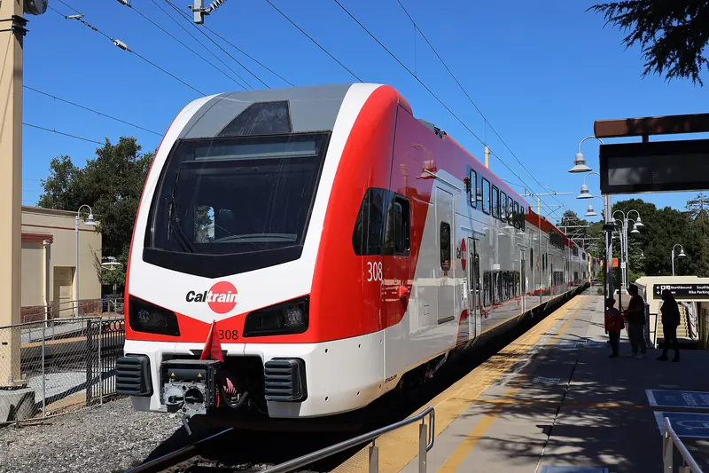
The South San Francisco station sits just east of Highway 101 at the foot of Grand Avenue. It was completely rebuilt and moved a short distance south between 2017 and 2022. The new station opened in September 2021 and its pedestrian underpass, which leads under the tracks to a plaza on the downtown side, was finished in January 2022. Caltrain places the station in zone 1, so from Palo Alto in zone 3 it is a three-zone fare: $8.50 in October 2026 and $9.00 from January 1, 2027. On the late October weekday timetable an express took about 26 minutes and a local about 35. Not every train stops, so check the timetable and see our Caltrain guide.
BART
BART's South San Francisco station is on the west side of town near El Camino Real, far from Grand Avenue. From Palo Alto you would ride Caltrain to Millbrae and then BART north, which takes longer than staying on Caltrain. BART is useful mainly if you are heading for the neighborhoods near El Camino.
Car
Take Highway 101 north. Use the Grand Avenue exit for downtown and the east side, or Oyster Point Boulevard for the marina and the ferry terminal. Parking is easy at Oyster Point and metered or time-limited downtown.
The Oyster Point ferry
South San Francisco has the only operating ferry terminal in San Mateo County. San Francisco Bay Ferry started the route in June 2012. It links Oyster Point with Oakland and Alameda on a weekday commute schedule, aimed at East Bay workers heading for the biotech campuses. A free shuttle sponsored by local employers, open to the public, runs during commute hours between the terminal, the Oyster Point office parks and the Caltrain station.
Ferry status, late 2026
- The South San Francisco route is suspended from November 1 to 30, 2026 while crews dredge the channel at the Oyster Point terminal.
- The last trips before the pause ran on Friday, October 30.
- Service is expected to resume on December 1, 2026 with the existing schedule. Check San Francisco Bay Ferry before you travel.
The ferry is not a practical way to reach Palo Alto, but it is a scenic way to cross the bay on a weekday. Our page on getting here from the East Bay covers the other crossings.
The Industrial City
South San Francisco was planned as an industrial town. In 1888 Gustavus Swift, founder of the Swift meatpacking company, proposed a shared stockyard on the bay with homes for workers nearby. He borrowed the name from South Chicago and South Omaha, where his company already had plants. A land company bought the property in 1890 and 1891, laid out industrial and residential districts and opened stockyards and packing plants in 1892. Brickworks, a paint factory, lumber yards and steel mills followed.
The city incorporated on September 19, 1908, after a fight with the county over a proposed smelter. By the 1920s it was known as the smokestack capital of the Peninsula. In 1923 the motto went up in giant letters on the hillside north of town. During World War II, the Western Pipe and Steel shipyard on the bay launched 48 ships between 1940 and the end of the war.
After the war the heavy plants closed one by one. Warehouses, office parks and new subdivisions such as Westborough took their place. The hillside sign stayed and was added to the National Register of Historic Places in 1996.
Genentech and the birth of biotech
In 1976 the venture capitalist Robert Swanson and the biochemist Herbert Boyer founded Genentech to turn recombinant DNA research into medicines. Boyer, a UCSF scientist, had shown with Stanley Cohen of Stanford how to cut and splice DNA. In 1977 Boyer's group, working with researchers at the Beckman Research Institute, became the first to express a human gene in bacteria, producing the hormone somatostatin. Kleiner Perkins backed the company early, a story told on our Kleiner Perkins page.
Genentech built its campus on the South City bayfront and stayed. Roche bought a majority stake in 1990 and the rest of the company in 2009 for about $46.8 billion. Genentech now runs as an independent subsidiary and remains headquartered here, with around 12,100 employees in 2026 according to Wikipedia. Dozens of other life science companies followed it to the east side of Highway 101. A sign on East Grand Avenue declares the city the Birthplace of Biotechnology.
The campus is a working site, not an attraction. We found no public tours. You can see the buildings from East Grand Avenue and the Bay Trail. For the investors behind the industry, see our guide to biotech and health investors.
Grand Avenue and downtown
Downtown South City runs along Grand Avenue west of Highway 101, roughly between Airport Boulevard and Spruce Avenue. It is an old-fashioned main street with family restaurants, bakeries, taquerias, Filipino and Asian places, bars and small shops. It feels much more like a working town than a Peninsula boutique strip. Some landmarks to look for:
- City Hall, 400 Grand Avenue, opened in 1920 and modeled on Independence Hall in Philadelphia.
- The 1916 Carnegie library building beside it, part of the Grand Avenue library.
- The 1912 Metropolitan Hotel, built by the meatpacking interests, with a city history mural high on its east wall.
- The Plymire-Schwartz House, built in 1905 and once the north Peninsula's first hospital, now run by the local historical society.
- The Linden Avenue post office, with a 1930s fresco mural by Victor Arnautoff.
Shops and restaurants change, so we name none here. Walk Grand Avenue and the side streets around Linden Avenue and pick what looks good.

Sign Hill, Oyster Point and the bay
Sign Hill Park protects about 30 acres of open space on the slope under the famous letters, with almost 2 miles of trail. The climb is short but steep. The view takes in the airport, the bay and the city. San Bruno Mountain, a state and county park, rises just behind it.
Oyster Point Marina and Park is a public marina of about 400 berths with a 33-acre park built over a closed landfill. It has small beaches, a fishing pier, picnic areas and a boat launch. The Bay Trail follows the shore past the lab buildings, with views of jets landing at SFO.
The Wind Harp, a 92-foot steel sculpture by Lucia and Aristides Demetrios built in 1967, stands in an office park on the east side. It hums when the wind blows through it.
Staying near SFO
The southern part of the city, nearest the airport, is lined with hotels, airport parking lots and car service shops. Wikipedia counts more than thirty hotels with over 2,700 rooms. They suit a late arrival or an early flight. You can compare South San Francisco hotels near SFO, then take Caltrain to Palo Alto the next day. Our SFO guide covers the routes.
Why a Palo Alto visitor might go
- Biotech history. Silicon Valley's sister industry was born here. Pair it with our Silicon Valley history.
- A real main street. Grand Avenue is unpolished and full of family businesses.
- A short, steep hike. Sign Hill gives a big view for little time.
- A bay ferry ride. On weekdays outside November 2026, the Oyster Point ferry crosses to Oakland and Alameda.
Good to know
- The Caltrain station is east of Highway 101, but the underpass puts you on the downtown side in a few minutes.
- Wind and summer fog are common here. Bring a jacket even when Palo Alto is warm.
- The ferry and its connecting shuttles run on weekday commute schedules only.
- South San Francisco is a separate city from San Francisco, with its own government.
Frequently asked questions
Is the South San Francisco ferry running?
Not in November 2026. San Francisco Bay Ferry suspended its South San Francisco route from November 1 to 30, 2026 while crews dredge the channel at the Oyster Point terminal. The last trips before the pause ran on Friday, October 30. Service is expected to resume on December 1 with the existing schedule.
Why is South San Francisco called the birthplace of biotechnology?
Genentech, widely regarded as the first biotechnology company, was founded in 1976 by venture capitalist Robert Swanson and biochemist Herbert Boyer and grew up in South San Francisco. Its success drew many other life science companies to the city's bayfront. A sign on East Grand Avenue declares the city the Birthplace of Biotechnology.
Can you visit Genentech?
Genentech's campus is a working research and office site, not a visitor attraction. We found no public tour program. You can see the buildings from East Grand Avenue and the Bay Trail. The city's Birthplace of Biotechnology sign is on East Grand Avenue.
How do I get to South San Francisco from Palo Alto by train?
Take Caltrain north to South San Francisco station. It is a three-zone fare, $8.50 in October 2026 and $9.00 from January 1, 2027. On the late October 2026 weekday timetable an express took about 26 minutes and a local about 35. The rebuilt station has an underpass to downtown Grand Avenue.
Can you hike to the South San Francisco sign?
Yes. Sign Hill Park is a city park with about 30 acres of open space and almost 2 miles of trails up to the big concrete letters. The sign, which reads South San Francisco The Industrial City, has been on the National Register of Historic Places since 1996. Wear good shoes, since the trails are steep.