Palo Alto runs from tidal marsh at the edge of the bay to oak woodland in the Santa Cruz foothills. Here is where to walk, ride and watch birds, plus the rules that trip people up.
Few cities this size have as much open land as Palo Alto. The city limits stretch from the edge of San Francisco Bay to the ridges above Interstate 280. A big share of that ground is protected. On the east side you get salt marsh, levee trails and some of the best birding on the West Coast. On the west side you get golden grass, oak woodland and long views from the foothills. Stanford's land sits in between with the most famous walk in town.
This guide gives you the lay of the land. It covers the three big city preserves, the smaller ones, the Stanford trails, the neighborhood parks and the best ways to get around by bike. The final sections cover birding and the rules for dogs, which differ more from place to place than most visitors expect.
Palo Alto outdoors at a glance
If you only have a morning, pick one of these based on what you want:
A classic workout with a view: the paved loop at the Stanford Dish, about 3.5 miles with real hills.
Easy hills with dogs or bikes: Pearson-Arastradero Preserve off Arastradero Road.
Kids who need to burn energy: Mitchell Park and the Magical Bridge Playground. See our guide to Palo Alto with kids.
The weather helps. Rain falls mostly from November to March and summers are dry, so trails are open nearly all year. Summer afternoons in the foothills can be hot and the bay shore can be windy. Check our weather guide before you plan a long day.
The Baylands Nature Preserve
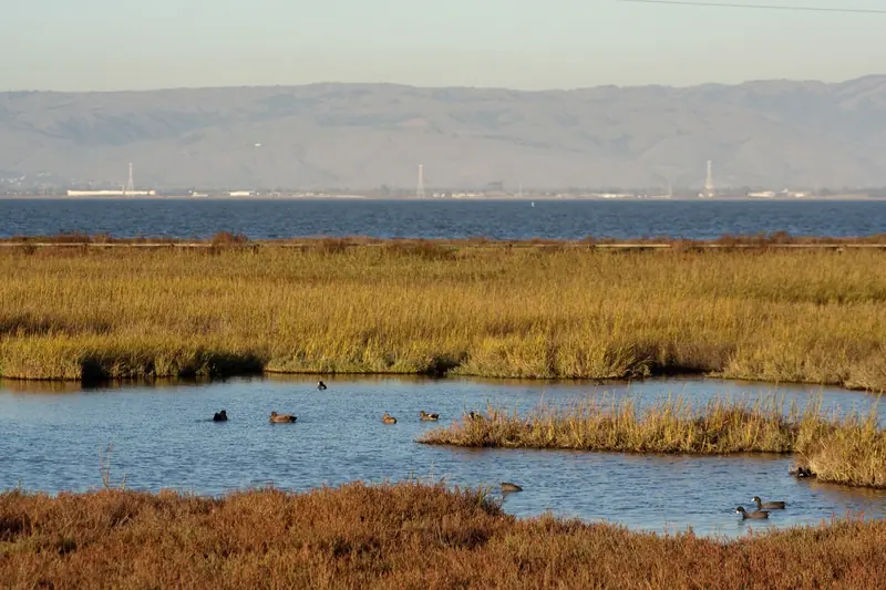
The Baylands Nature Preserve covers 1,940 acres at the east end of Embarcadero Road. The city calls it one of the largest tracts of undisturbed marshland left on San Francisco Bay. About 15 miles of multi-use trails run along the levees, past tidal sloughs, freshwater ponds and open mudflats.
Start at the Lucy Evans Baylands Nature Interpretive Center. The building stands on pilings at the edge of the marsh. A boardwalk about a quarter mile long runs from it across the pickleweed to open water. The boardwalk was rebuilt and reopened in 2019 after years of partial closure. Nearby you will find the Duck Pond, which began life as a saltwater swimming pool in the 1930s. The grassy hills of Byxbee Park rise just to the south.
The Baylands are at their best in winter, when migrating ducks and shorebirds arrive by the thousands. Sunsets over the marsh are also hard to beat. Our full Baylands guide covers trails, birding seasons and parking.
Pickleweed and tidal channels at the Baylands. The marsh turns red and gold in the fall. Photo: J Doll, Wikimedia Commons, CC BY 3.0
Advertisement
Foothills Nature Preserve
Foothills Nature Preserve sits off Page Mill Road above Interstate 280. It covers about 1,400 acres, close to a tenth of the land in Palo Alto. Most of it was bought from the physician Russel Lee after voters approved the purchase in 1959. The park opened in 1965 as Foothills Park.
For most of its life the park admitted only Palo Alto residents and their guests. After protests and a lawsuit, the city opened it to everyone on December 17, 2020. The City Council renamed it Foothills Nature Preserve in 2021. Today there is a daily vehicle fee and a cap on the number of visitors inside at one time.
Inside you will find Boronda Lake, a nature interpretive center, picnic lawns and about 15 miles of trails. Vista Hill looks out over the bay on clear days. Our Foothills Nature Preserve guide covers fees, the capacity limit and the best loops.
Pearson-Arastradero Preserve and Esther Clark
Enid W. Pearson-Arastradero Preserve is the friendly middle ground between the flat bay and the steeper foothills. It covers 622 acres of rolling grassland and oak woodland at 1530 Arastradero Road. About 10 miles of trails loop through it. Hikers, cyclists and horseback riders share them, so bikes are welcome here in a way they are not on most Foothills trails.
The trail map lists short loops that suit most fitness levels. The Redtail Loop climbs steeply through grassland for about 1.5 miles. The Arastradero Creek Trail follows a shaded creek for about 1.4 miles. A side trail leads to small Arastradero Lake. A gateway visitor center near the parking lot has a scale model of the preserve and exhibits on local plants and animals.
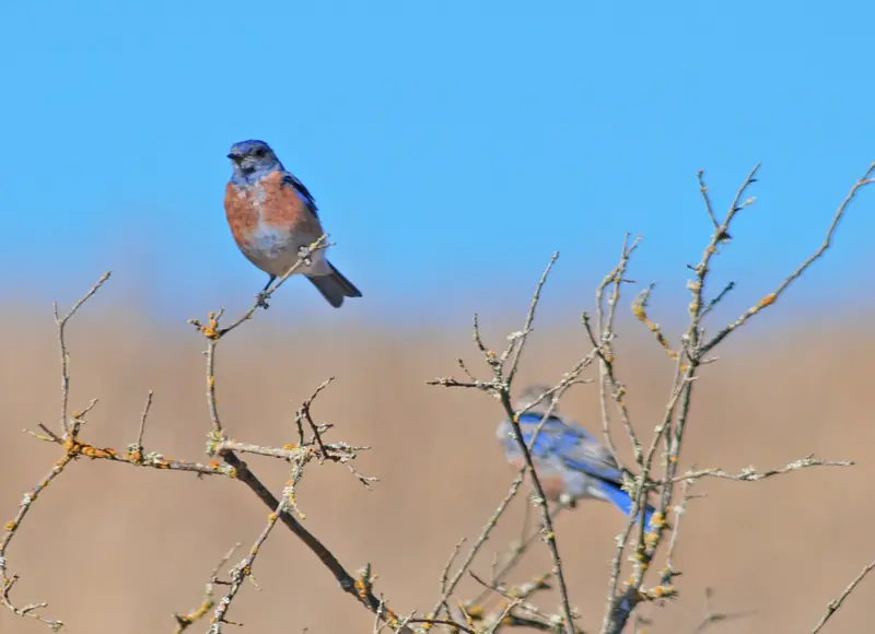
The preserve is open from 8 a.m. to sunset. Some trails are seasonal and close after heavy rain until the ground firms up. Dogs must be on leash. Deer, coyotes and bobcats live here and western bluebirds are common in the open grassland.
Esther Clark Park is a much smaller and quieter preserve of grass and oaks in the foothills on the city's southwest edge. It has no facilities to speak of. It is a good spot to sit with a view at sunset. Dr. Esther Clark, a founder of the Palo Alto Medical Clinic, sold the land to the city on the condition that it stay open space.
Western bluebirds at Pearson-Arastradero Preserve. Look for them on fence posts and low branches. Photo: Schmiebel, Wikimedia Commons, CC BY-SA 3.0
The Dish and Stanford trails
The Dish is the walk that everyone in town seems to know. It loops through Stanford's foothills around a 150-foot radio telescope built in 1961. The paved route is about 3.5 miles with steady climbs and almost no shade. Stanford sets its own hours by month and bans dogs and bikes. Read our Dish guide for entrances, hours and tips.
Stanford also maintains other walking routes. The university lists the Perimeter Trail and the Matadero Deer Creek Trail as nearby options. The flat campus itself makes a fine walk. Start on Palm Drive, then circle the Main Quad and the Arizona Cactus Garden. Our Stanford visitor guide has the details.
Advertisement
City parks worth knowing
Rinconada Park
Rinconada Park on Middlefield Road is the city's classic central park. It has big shade trees, picnic lawns, playgrounds and the public Rinconada Pool. The Junior Museum and Zoo sits right next door. It is an easy stop if you are staying near downtown or exploring Crescent Park and the older neighborhoods.
Mitchell Park
Mitchell Park is a 21.4-acre district park in south Palo Alto. It holds the Magical Bridge Playground, which opened in 2015 and was designed so children and adults of every ability can play together. The park also has tennis and pickleball courts, a fenced dog park and the Mitchell Park Library next door.
Bol Park and its bike path
Bol Park sits in Barron Park. A paved path runs through it along an old rail line and continues toward the Gunn High School area. It is one of the most pleasant car-free connections in the city and a handy way to reach Arastradero by bike.
Biking in Palo Alto
Palo Alto is flat on its eastern side and built around bikes. The best-known route is the Bryant Street bike boulevard. Palo Alto created the first bicycle boulevard in the United States here. It is now named for Ellen Fletcher, a Holocaust survivor and one of the country's first bike activists. The street is designed to keep car traffic light and slow, so riders can cross much of the city north to south on quiet streets.
Other good rides:
The Bay Trail and Baylands levees. Flat gravel and paved paths along the shore. Wind picks up most afternoons.
Bol Park path to Arastradero. A gentle climb from Barron Park into the preserve, where bikes are allowed on most trails.
Page Mill Road and the foothills. A serious road climb shared with cars. Bikes may only use the paved roads inside Foothills Nature Preserve.
Stanford campus. Flat and full of bike lanes. Watch for student traffic between classes.
Birders come to Palo Alto from far away for the Baylands. Winter is peak season. From late fall through early spring the marsh fills with ducks, avocets, stilts, curlews and other shorebirds on the Pacific Flyway. The highest winter tides push secretive marsh birds such as the endangered Ridgway's rail toward the edges, where they are easier to spot.
The foothills offer a different list. Look for acorn woodpeckers in the oaks on the Dish, wild turkeys on the lawns at Foothills Nature Preserve and western bluebirds and hawks over Arastradero. Bring binoculars and arrive early. Birds are most active in the first hours after sunrise and the trails are quieter too.
Dogs and trail rules
Rules change from one preserve to the next. Here is a quick summary, but always check the city's rules page before you go.
Place
Dogs
Bikes
Baylands Nature Preserve
On leash, not on Renzel Ponds trails
Yes, helmet required
Foothills Nature Preserve
On leash, weekdays only
Paved roads only
Pearson-Arastradero Preserve
On leash
Yes, helmet required
Esther Clark Park
On leash
Yes, helmet required
Stanford Dish
No, except service animals
No
In open space the leash can be no longer than six feet. Dogs can run free only in the city's fenced dog parks at Mitchell, Peers, Greer and Hoover parks. The dog park page lists the rules, including a limit of three dogs per person.
Good to know
Most city preserves open at 8 a.m. and close at sunset. Gates lock at closing time.
Drones and other remote-control devices are banned in the preserves.
Smoking, fires and feeding wildlife are banned across the open space system.
Poison oak, ticks and rattlesnakes are part of life in the foothills. Stay on marked trails.
The Stanford Dish loop is the most popular choice. It is a paved path of about 3.5 miles with steady hills and wide views. For flat walking, the levee trails at the Baylands Nature Preserve are easier and good for birding.
Is Foothills Nature Preserve open to non-residents?
Yes. The park was residents only for decades but opened to everyone on December 17, 2020. The city charges a daily vehicle fee and limits how many people can be inside at once, so the gate can close on busy weekends.
Can I bring my dog on Palo Alto trails?
Dogs are allowed on leash in the Baylands and Pearson-Arastradero Preserve. Foothills Nature Preserve allows leashed dogs on weekdays only. Dogs are not allowed on the Stanford Dish except service animals.
Where can I ride a bike in Palo Alto?
The Bryant Street bike boulevard runs north to south through the city with few cars. The Bay Trail and Baylands levees are flat and scenic. Bol Park bike path links Barron Park to the Gunn High School area.
When are the open space preserves open?
The city's preserves are generally open from 8 a.m. to sunset. Exact closing times change with the season and are posted at each entrance. The Stanford Dish sets its own hours by month.