On this page
Page Mill Road is a Palo Alto name, but the road has a far end most residents never think about. In the 1880s the lumberman William Page ran a shingle mill deep in the Pescadero Creek canyon and built a haul road over the mountains to the Embarcadero in Palo Alto. Today that canyon is Portola Redwoods State Park, 2,800 acres of redwoods, creeks and ferns at the bottom of a steep, winding drive.
California State Parks runs it as a quiet getaway with 18 miles of hiking trails, a campground and one of the most remote old-growth groves in the region. Our waterfalls guide and camping guide introduce the park. This page covers the drive, the trails with State Parks' own distances, camping and its fall status, the rules and the history.
The drive from Palo Alto
Take Page Mill Road west from Interstate 280 all the way up to Skyline Boulevard (Highway 35). State Parks' directions pick up from there: turn west onto Alpine Road, go 3 miles and turn onto Portola State Park Road, which dead ends in the park. Use low gear. Both roads are steep and winding. Portola State Park Road drops from the ridgetop into the redwoods.
State Parks says that because of the mountain roads, most Bay Area visitors should expect 1.5 to 2 hours. From Palo Alto the trip is shorter, roughly an hour, but allow extra time for slow traffic on Page Mill.
Before you leave town
- Gas: none at or near the park. State Parks says the nearest station is at Sky Londa, at Highways 84 and 35, about 14 miles away.
- Food: no store in or near the park. The nearest groceries are in Sky Londa and La Honda, about 9 miles away on Highway 84.
- Cell service: none in the park or the area around it. Ridesharing is not recommended.
- Maps: download one before you go. Free park maps are available at the visitor center.
Fees, hours and the visitor center
- Day use: 6 a.m. to sunset. State Parks notes the park may close in severe weather.
- Vehicle fee: $10, or $9 for seniors 62 and older. Buses pay $50 or $100 depending on size.
- Visitor center: the main park page lists it as open daily, 9 a.m. to 5 p.m. The trails page says it is staffed on weekends and holidays year-round as staffing permits, so call ahead on a weekday.
- Facilities: restrooms, drinking water, picnic areas and pay showers in the campground.
The visitor center itself is part of the story. With its couches and fireplace, State Parks says it feels like a wilderness lodge. It began as the recreation hall of a Shriners' summer retreat. Check the official park page for current hours and alerts.
The old-growth trails
All 18 miles of trail are for hikers only. State Parks' published routes:
| Trail | Distance | Elevation change | Start |
|---|---|---|---|
| Old Tree Trail | 1.2 miles round trip | 245 feet | Old Tree trailhead |
| Sequoia Nature Trail | 0.75 miles | 67 feet | Behind the visitor center |
| Tiptoe Falls | 1.44 miles | 172 feet | Behind the visitor center |
| Upper Coyote and East Tarwater | 6-mile loop | 760 feet | Iverson trailhead |
| Peters Creek Loop | 11.9 miles round trip | 1,030 feet | Old Tree trailhead |
Old Tree and Shell Tree
The Old Tree Trail is an easy walk near the campground with interpretive signs. At the end a single huge redwood stands alone. State Parks says Old Tree is about 1,200 years old and one of only 14 redwoods in the Santa Cruz Mountains taller than 300 feet. The park describes the walk as 1.2 miles round trip in its trail table and 0.6 miles round trip in its summary, so plan on the longer figure.
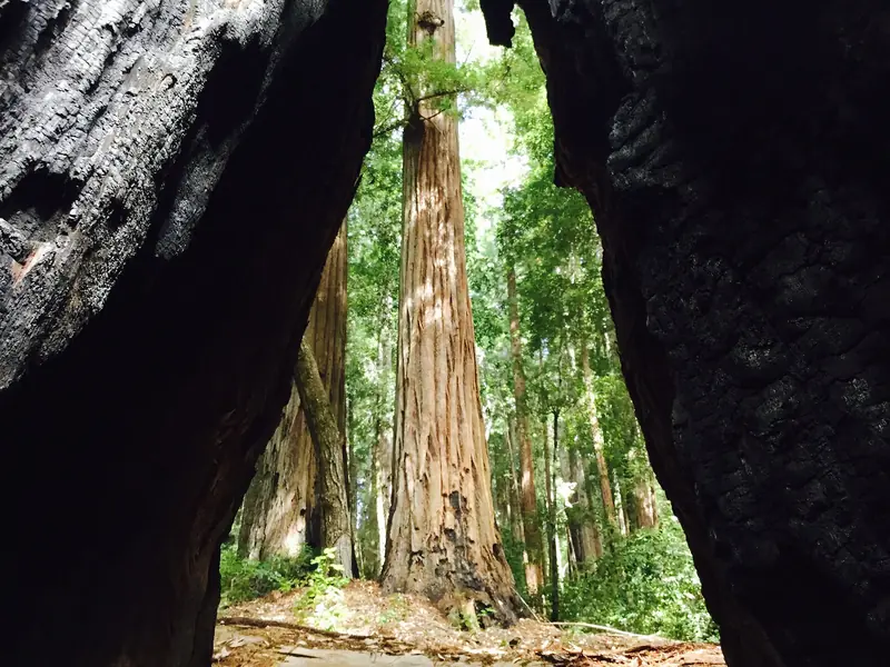
The Sequoia Nature Trail loops past Shell Tree, the remains of a redwood destroyed by a camper's fire in 1989. State Parks says it was 17 feet across and about 2,000 years old. In summer a seasonal bridge crosses Pescadero Creek; in winter you rock hop or wade. The park advises against crossing if the water is above your knees. Ask at the visitor center whether the bridge is in.
Tiptoe Falls
From the Sequoia Nature Trail, the Iverson Trail leads through streamside redwoods and huckleberries to a short spur and Tiptoe Falls, a small cascade through a rocky notch on Fall Creek. Look for salamanders in the pool. In autumn, State Parks says, yellow maple leaves light up the forest.
The Peters Creek Grove
The park's big day hike reaches its backcountry old-growth grove. From the Old Tree trailhead, follow the Slate Creek Trail 2.5 miles to the trail camp, take the Bear Creek Trail about 2.5 miles more, loop around the grove and return the same way: 11.9 miles with 1,030 feet of elevation change. State Parks calls the Peters Creek Grove some of the most remote and scenic redwoods in the region. Our redwood forests guide compares it with Big Basin and Muir Woods.
Camping and its fall status
State Parks lists a 55-site family campground. Each site holds up to 8 people and two cars; one is wheelchair accessible and four require a short walk from parking. There are no hookups. RVs may use sites 1, 4, 7, 8, 9 and 19, with a maximum length of 21 feet for trailers and 24 feet for motor homes. Check-in is 2 p.m. and checkout is noon. Pay showers cost 25 cents for two minutes.
- Group camps: four tent-only sites. Ravine holds 25 people; Hillside, Point and Circle hold 50 each. Reservations required.
- Hike-and-bike: four first come, first served sites at Huckleberry Campground.
- Slate Creek Trail Camp: 2.5 miles from the Old Tree trailhead, with 6 sites for up to 6 people each. No fires, but backpacking stoves are allowed. Pack in water or treat it from Slate Creek about a quarter mile away. No dogs. Reserve through the State Parks backcountry trail camp request form up to 60 days ahead.
Family and group sites book through ReserveCalifornia, online or at 1-800-444-7275, up to 6 months ahead starting at 8 a.m. On October 30, 2026 the park page showed "No upcoming camping/lodging reservations at this time." State Parks does not explain whether that means the campground is sold out, between seasons or closed. Its camping page also warns that fall and winter storms can force the park to close and relocate campers, with a refund or a site at another park. Check ReserveCalifornia or call the park before planning a winter trip.
Dogs, bikes and horses
- Dogs: allowed only in campsites, picnic areas, parking lots and on paved roads, plus the Upper and Lower Escape Roads loop along Peters Creek at the north end of the campground. Leash of 6 feet or less, attended at all times and inside a tent or vehicle at night. No dogs on hiking trails, dirt roads or in the visitor center. See our dog-friendly hikes guide for better dog options.
- Bikes: paved roads and the service road past the Iverson Cabin site only. That road continues through Pescadero Creek County Park on Old Haul Road to Memorial County Park, a 10-mile round trip State Parks calls one of the most scenic beginner rides in the Bay Area. Helmets are required under 18.
- Horses: same as bikes, paved roads and the service road only.
- Crumb Clean: jays, ravens and crows drawn to scraps eat the eggs and chicks of the endangered marbled murrelet. State Parks asks visitors to watch its short Crumb Clean video and leave no food out.
- Firewood: buy it at the park office or from the camp host. Do not gather wood. Drones are prohibited.
Winter trails and safety
State Parks' trail page reads like a winter checklist. All trails close at sunset. Expect mud for days after rain, since the redwood forest dries slowly. Expect fallen trees you must climb over or around. Small streams can become dangerous after storms. When in doubt, turn back. Carry a map, water, warm clothes and a flashlight in case you are caught out after dark.
In dry months, poison oak and ticks are the main concerns. Mountain lions live throughout these mountains; keep children close on the trail. Use only the campground fire rings. State Parks can restrict fires during high fire danger.
History
State Parks says the Quiroste people lived in this area, fishing for steelhead and coho salmon and collecting natural asphaltum from Tar Creek as a sealant. A trade route between the coast and the interior passed through the park. The park is named for Gaspar de Portolá, whose 1769 expedition traveled up the San Mateo coast but never reached this spot.
Danish immigrant Christian Iverson built a cabin on Pescadero Creek in the 1860s and split redwood shakes for a living. In 1889 he sold to William Page, whose mill road became Page Mill Road. In 1924 John A. Hooper sold more than 1,600 acres to the Islam Shrine of San Francisco for a summer retreat. When membership dropped, the Shriners sold to the state for $112,500, half the appraised value. The park opened in 1945 and has since doubled in size, helped by groups such as Save the Redwoods League. For more on Palo Alto's own past, see our history of Palo Alto.
What pairs nearby
- Sam McDonald County Park: more redwoods just down the canyon in San Mateo County.
- Russian Ridge: grassland views at the top of Page Mill on the drive home.
- Pescadero and the coast: continue west for a coastal loop.

Frequently asked questions
How do I get to Portola Redwoods State Park from Palo Alto?
Drive Page Mill Road up to Skyline Boulevard, cross onto Alpine Road and go west 3 miles, then turn onto Portola State Park Road, which dead ends in the park. State Parks says to use low gear because both roads are steep and winding. Fill up first: the nearest gas is at Sky Londa, 14 miles away.
Is camping open at Portola Redwoods?
The park has a 55-site family campground, four group camps, four first come hike-and-bike sites and the Slate Creek trail camp, booked through ReserveCalifornia and the State Parks trail camp system. On October 30, 2026 the park page showed no upcoming camping reservations. State Parks also warns that fall and winter storms can force campers to relocate. Check ReserveCalifornia or call (650) 948-9098.
What is the best short hike at Portola Redwoods?
The Old Tree Trail leads to a single giant redwood that State Parks says is about 1,200 years old and one of only 14 redwoods over 300 feet tall in the Santa Cruz Mountains. The park gives the walk as 1.2 miles round trip in one place and 0.6 miles in another. Tiptoe Falls, at 1.44 miles, is the other favorite.
Are dogs allowed at Portola Redwoods?
Only in campsites, picnic areas, parking lots and on paved roads, plus the Upper and Lower Escape Roads loop at the north end of the campground. Dogs must be on a leash no longer than 6 feet and are not allowed on hiking trails, dirt roads or in the visitor center.
Can I bike at Portola Redwoods?
Only on paved roads and the service road past the Iverson Cabin site, which connects to Old Haul Road in Pescadero Creek County Park. State Parks calls it one of the most scenic beginner rides in the Bay Area, a 10-mile round trip to Memorial County Park. Bikes are not allowed on hiking trails.