On this page
El Corte de Madera Creek is the Skyline preserve that mountain bikers talk about. The Midpeninsula Regional Open Space District, known as Midpen, manages 2,908 acres here with more than 34 miles of multiuse trail. It calls the preserve extremely popular with bicyclists but also full of hearty hiking and riding. Expect creekside trails through mixed evergreen and redwood forest, ocean views, rare sandstone formations and what Midpen calls a sense of remoteness.
The name roughly means "cutting wood" in Spanish. Logging shaped almost every acre. Old logging roads became today's trails and the deep canyons grew back into dense second-growth redwood. A few giants survived. This guide covers parking, the best short hikes, the bike and horse rules and the history, from the sawmills to a 1953 plane crash. For the wider picture of the Woodside side of the hills, see our Woodside and Atherton guide.
Getting there and parking
From Palo Alto, take Interstate 280 north to Woodside Road (Highway 84) and follow it west through Woodside and up the hill to Skyline Boulevard (Highway 35). Turn right and head north. Midpen puts the main El Corte de Madera Parking Area about 2.7 miles north of the Skyline and Highway 84 intersection. You can also come up Kings Mountain Road past Huddart Park and turn left on Skyline. Both roads are narrow and twisty. There is no transit to any of these trailheads.
| Parking area | Spaces | Notes |
|---|---|---|
| El Corte de Madera Parking Area | 65 | West side of Skyline, about 1 mile south of Skeggs Point; equestrian trailer parking |
| Skeggs Point (Caltrans) | 26 | East side of Skyline, about 4 miles north of Highway 84 and 1.5 miles south of Kings Mountain Road; no left turn in from the north |
| Methuselah roadside | 5 | Small pullout |
| Gordon Mill roadside | 5 | Small pullout |
| Star Hill roadside | 6 | Small pullout |
Skeggs Point is the usual start for the Tafoni Trail, via the El Corte de Madera Creek Trail entrance across the road. Cross Skyline with care. Cars and motorcycles move fast on this stretch. Midpen lists restrooms as available in the preserve. It reminds visitors to lock cars and keep valuables out of sight.
Midpen does not list an entry or parking fee here. Skeggs Point belongs to Caltrans, so follow its posted signs. The preserve opens half an hour before sunrise and closes half an hour after sunset.
Trails and highlights
Midpen does not publish a single signature loop for this preserve. The trail web is dense. Download the official map before you lose cell service. These are the features Midpen highlights.
Tafoni and the Fir Trail vista
Tafoni are cave-like hollows and delicate honeycomb patterns that weather carves into sandstone over hundreds of years. Midpen built an observation deck at the formation off the Tafoni Trail and asks visitors to admire it from there rather than climb the rock. On the way, take a short detour on the Fir Trail to a vista point. Midpen says it looks over the forested Santa Cruz Mountains and grassy coastal hills to the Pacific Ocean.
Timberview Trail and the old-growth giant
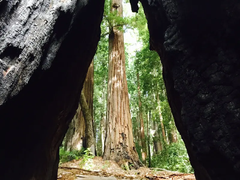
To see one of the remaining old-growth redwoods, Midpen sends hikers to the Timberview Trail near its junction with the Giant Salamander Trail. The tree is about 50 feet around at its base. It stands so tall that, in Midpen's words, there is barely room to step back and take it in.
Oljon Trail
The newest trail opened in 2019 as a segment of the Bay Area Ridge Trail. It follows a redwood-forested ridgeline on the western slope, past sandstone outcrops and old stumps. Some stumps still show springboard notches, the slots loggers cut to stand on while sawing. Building it meant removing part of the old Steam Donkey Trail and restoring old logging roads. Midpen calls it the final piece of an 18-year watershed protection program for fish habitat and forest health.
Resolution Trail
This single-track trail winds through the canyon below a knoll off the Fir Trail. It is named for the DC-6 airliner Resolution, which crashed here in 1953. A memorial plaque stands along the route. Midpen asks visitors to leave any artifacts where they find them.
Sierra Morena and Manzanita trails
The Sierra Morena Trail runs through lush mixed evergreen forest from the main lot west of Skyline. Midpen lists it as easy access but warns that it is narrow and popular with mountain bikers. The Manzanita Trail climbs through a stand of Kings Mountain manzanita, a plant native to this area, to a hilltop that Midpen says has top-of-the-world views toward the ocean.
The Methuselah Tree
Across Skyline Boulevard stands Methuselah, a redwood Midpen says is about 1,800 years old. It calls it the largest redwood in the Santa Cruz Mountains outside Big Basin. The tree is on California Water Service land and the company allows public access. Our redwood forests guide covers Big Basin and other big-tree trips.
Mountain biking
Midpen's biking page describes 34 miles of multiuse trail here, including some steep, technical single track, in rugged, heavily forested terrain. Bikes are allowed on designated trails only, marked on the map. The rules:
- Helmets are required, even when riding uphill, with straps fastened.
- The speed limit is 15 mph, or 5 mph when passing or on blind turns. Racing and reckless riding are prohibited.
- Off-trail riding, including jumps and wall rides, is prohibited.
- E-bikes are not allowed on most Midpen trails. Midpen allows them for people with a mobility disability on trails open to bikes.
- Cyclists yield to everyone. Announce yourself when you come up behind hikers or riders.
Midpen notes bike racks and tire cleaning stations at some preserves. Trails can turn muddy after winter storms. Our biking guide covers easier rides closer to town and our cycling clubs page lists group rides.
Dogs, horses and other rules
- Dogs: not allowed in this preserve. Service dogs are accommodated. Our dog-friendly places guide lists Midpen preserves that do allow leashed dogs.
- Horses: the regulations say horses are allowed on designated trails marked on the map. Helmets are recommended. The summary panel on the same page lists equestrians on all trails. Follow the map and posted signs. Everyone yields to riders. Trailer parking is at the main lot.
- Current closure: Midpen lists the Methuselah Trail as closed to equestrians from the Giant Salamander Trail to the South Leaf Trail because of trail damage.
- Groups: a permit is needed for any event of 20 or more people, or one that charges a fee.
- Also prohibited: drones and model aircraft, fires, smoking, swimming or wading and weapons. Do not disturb plants or wildlife.

Seasons and events
Winter rain brings running creeks, banana slugs and the deepest greens. Trails can be slick and the bike-heavy routes rut up, so give them time to dry. Spring is mild under the trees. Summer is a good time to visit because the redwood canyons stay cooler than the open ridges, although fog often sits on Skyline. Fall can bring clear views to the ocean and also fire weather.
Midpen's calendar lists Hiking the Highlights on November 2, Finding Awe in Nature on November 5, Winter Wonders: Banana Slugs and More on December 8, Old Growth, New Growth on December 11 and a Ride the Redwoods bike outing on December 13, 2026. In Search of Manzanitas follows on January 3, 2027. See our nature programs guide for more guided outings.
Safety
There is no drinking water on the trails. Midpen recommends two quarts per person for every two hours of hiking. Cell service is very sporadic. In an emergency, call 911. For anything else, call Midpen at 650-691-1200.
- Mountain lions are a natural part of this region and are occasionally seen. If you meet one, do not run. Keep children close, face the lion, stand tall and make noise, then leave and warn others. Report sightings to 650-691-2165.
- Ticks are present and may carry disease. Check yourself after the hike.
- Poison oak grows on most preserves. Learn it in every season.
- Rattlesnakes are especially active in warm weather.
- Bikes: on narrow trails, listen for riders and step aside to let them pass.
History
Midpen says the steep, remote terrain kept loggers out until the 1860s, when San Francisco's growth after the gold rush created demand for redwood lumber. Entrepreneurs then spent about 50 years building and running mills beside the creeks. Midpen's history counts eight mills; another Midpen page says the area had up to 15 sawmills in the late 1800s. Most closed around 1900. Selective logging continued until 1988, shortly after the preserve was created. Look for flattened pads where mills or cabins stood and rusted equipment left behind.
On October 29, 1953, a DC-6 named Resolution, flying from Australia, approached San Francisco airport in dense fog and hit a ridge in what is now the preserve. All eight crew members and 11 passengers died, including the American pianist William Kapell. Midpen calls it San Mateo County's deadliest plane crash. The knoll off the Fir Trail served as the base for rescue crews. Our hiking guide compares this preserve with other trails near town.
Frequently asked questions
Where do you park for the Tafoni Trail?
Midpen sends visitors to the Caltrans Skeggs Point parking area on the east side of Skyline Boulevard, about 4 miles north of Highway 84. It has 26 spaces. The trail entrance is across the road. Midpen notes that drivers coming from the north may not turn left into the lot.
Are dogs allowed at El Corte de Madera Creek Preserve?
No. Midpen does not allow dogs in this preserve. Service dogs are accommodated under the Americans with Disabilities Act. Nearby La Honda Creek Preserve and Thornewood Preserve have trails where leashed dogs are allowed.
Can you mountain bike at El Corte de Madera?
Yes, on designated trails marked on the map. Midpen calls the preserve extremely popular with bicyclists and lists 34 miles of multiuse trail, including steep, technical single track. Helmets are required and the speed limit is 15 mph, or 5 mph when passing. E-bikes are not allowed on most Midpen trails.
Is there an old-growth redwood at El Corte de Madera?
Yes. Midpen points hikers to the Timberview Trail near its junction with the Giant Salamander Trail. The tree there measures about 50 feet around at its base. Across Skyline Boulevard, the Methuselah Tree on California Water Service land is about 1,800 years old.
Does it cost anything to visit?
Midpen does not list an entry or parking fee for this preserve. Its preserves are generally free to visit. Skeggs Point is a Caltrans lot. Check the posted signs and the preserve page before you go in case anything changes.