On this page
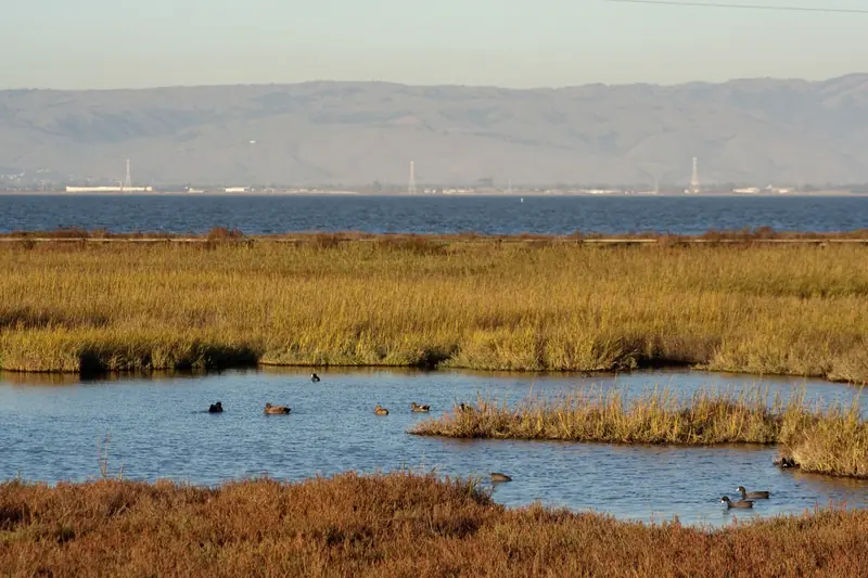
East of Highway 101, Palo Alto ends in salt marsh. The bay shore here is flat, open and nearly free of cars, with levee trails that run for miles past ponds full of ducks and stilts. This ride uses that shore to link two cities. It starts at California Avenue station, crosses the freeway on the Adobe Creek bridge, visits the Palo Alto Baylands, then heads south past the grassy hills of Byxbee Park into Shoreline at Mountain View. The last stretch follows the Stevens Creek Trail into downtown Mountain View, where Red Rock Coffee sits a block from the train.
It is a point-to-point ride designed around Caltrain, so you only ride each mile once. If you would rather loop back to a car, the out-and-back version from the Baylands lot is described below. For a broader guide to the shoreline trail, see our Bay Trail page.
The ride at a glance
We traced the route on OpenStreetMap with a cycling router and sampled U.S. Geological Survey elevation data. The distance depends on how far into the Baylands you go before turning south, so the numbers below are approximate.
| Section | Surface | Approximate distance |
|---|---|---|
| Cal Ave station to the Adobe Creek bridge | Quiet streets and paved paths | About 3.5 miles |
| Bridge north to the Baylands nature center | Paved and gravel | About 2 miles |
| Baylands south to Shoreline | Gravel levees, then paved | About 5.5 miles |
| Shoreline to Mountain View station | Paved Stevens Creek Trail and streets | About 4 to 5 miles |
| Total one way | About 15 to 17 miles, under 200 feet of climbing |
Start, parking and Caltrain
Take Caltrain to California Avenue station and finish at Mountain View station. Electric trains carry two bike cars each. On weekends, check that the train you want home lines up with your arrival.
If you drive, park free at the Baylands lots at the east end of Embarcadero Road and ride the shoreline section as an out-and-back. The preserve opens at 8 a.m. and closes at sunset; gates near the Duck Pond and the Byxbee Park hills lots close at the times posted on signs.
Turn by turn
- To Mitchell Park. From California Avenue station, ride east on the city's quiet bike streets toward Midtown and south to Mitchell Park on East Meadow Drive. Our bike boulevards page shows the network.
- Adobe Reach Trail. East of the park, follow East Meadow Drive and the Adobe Reach Trail to West Bayshore Road.
- Over Highway 101. Cross the freeway on the Adobe Creek bicycle and pedestrian bridge, open since November 2021.
- North to the Baylands. On the far side, follow the Bay Trail north along the levees to the Lucy Evans Baylands Nature Interpretive Center and the Duck Pond at the end of Embarcadero Road.
- Turn south. Ride back south along the marsh-front levees past the hills of Byxbee Park.
- Into Mountain View. Continue past Adobe Creek and the Charleston Slough into Shoreline at Mountain View, where the trail becomes paved.
- Shoreline Lake. Ride past Shoreline Lake and the Rengstorff House area to the mouth of Stevens Creek.
- Stevens Creek Trail. Turn south onto the paved trail and follow it under the freeways toward downtown. Leave the trail near Moffett Boulevard and ride to Castro Street and the station.

Surface, wind and traffic
This is the easiest ride on our list for traffic. Apart from the city streets at each end and a few road crossings, it is all paths. The surfaces vary. The levees through the Baylands are packed gravel, fine on a hybrid or a road bike with 28 mm tires when dry but sticky after rain. Shoreline and the Stevens Creek Trail are paved.
Wind is the real opponent. It usually builds after lunch and blows from the northwest, which on this route means a headwind as you ride north to the Baylands and a tailwind heading south. Riding in the morning keeps it gentle. The shore has no shade at all, so wear sunscreen even on cool days.
Paths are shared with walkers, runners, birders with scopes and families. Ring a bell, pass slowly and give people room. The city's Baylands rules set a 15 mph limit.
Water, restrooms and coffee
- Mitchell Park. The city lists restrooms at the park and the Mitchell Park Library next door has indoor restrooms during open hours. It is the most reliable stop near the start. Our Mitchell Park guide has details.
- The Baylands. We could not find restroom or water details on the city's Baylands pages in November 2026, though the preserve has buildings and lots near the nature center and Duck Pond. Do not count on them.
- Shoreline. The bistro at Shoreline Lake is closed for remodeling, so do not plan lunch there.
- Red Rock Coffee. At 201 Castro Street in downtown Mountain View, close to the station. Its website lists hours of 7:30 a.m. to 5 p.m. on weekdays (to 8 p.m. on Mondays) and 8 a.m. to 5 p.m. on weekends. It also posted November and December 2026 events and holiday hours. It closes on Thanksgiving and Christmas.
Carry at least one full bottle from the start. Our Castro Street guide lists more places to eat near the station.
Closures and construction
We checked the City of Palo Alto, the City of Mountain View and the U.S. Fish and Wildlife Service in early November 2026.
- Palo Alto Baylands and Byxbee Park. The city's preserve alerts page, updated September 18, 2026, listed no alerts, closures or notifications for either.
- Shoreline at Mountain View. The city lists the Pond A1 material import project from December 2024 through summer 2027. On weekdays from 7:30 a.m. to 4 p.m., while trucks are hauling, a short section of Shoreline trail closes, including part of the Bay Trail. The trails stay open when no hauling is happening. Weekends are clear.
- Stevens Creek Trail. The Fish and Wildlife Service is repairing the levees of Pond A2W from August 31, 2026 through November 2026. The Song Sparrow Spur Trail is closed and the northernmost end of the Stevens Creek Trail closes intermittently for deliveries. Construction trucks also use the trail in Mountain View. The service says no detour is needed because both are out-and-back trails north of the junction this route uses.
Safety
Good to know
- Helmets: required for everyone on Palo Alto preserve trails and for riders under 18 everywhere.
- Street sections: California law requires drivers to give cyclists at least 3 feet when passing. Use signals at East Meadow Drive, East Charleston Road and Shoreline Boulevard crossings.
- Lights: required after dark. The levees have no lighting and the wind often drops at dusk, which brings mosquitoes.
- Trucks: on weekdays, expect construction vehicles near Shoreline and on parts of the Stevens Creek Trail.
Seasons
Winter is the best time for birds, with ducks, shorebirds and raptors on every pond, but the gravel levees get muddy after rain and king tides can flood low spots. Use paved streets for a day or two after a big storm. Spring and fall bring mild days. Summer mornings are cool and gray near the bay, while afternoons bring strong wind. Daylight saving time ended November 1, 2026, so a winter afternoon ride needs lights for the trip home. Our Baylands Nature Preserve guide covers the marsh itself and our Shoreline Park guide covers the Mountain View end.
Frequently asked questions
How far is it from the Palo Alto Baylands to Shoreline by bike?
Along the shoreline trails it is roughly 5 to 6 miles from the Lucy Evans nature center in the Baylands to the Rengstorff House area of Shoreline at Mountain View, by our estimate. A round trip from the Baylands lot is about 11 to 12 miles. The ride is nearly flat.
Do you need a helmet in the Palo Alto Baylands?
Yes. The city's preserve rules require bicycle helmets for everyone on preserve roads and trails, not just riders under 18. The city also sets a 15 mph speed limit and bans skates and coasting devices because the roadways are narrow.
Are the Shoreline trails closed for construction?
In part. Mountain View lists a Pond A1 material import project from December 2024 through summer 2027. On weekdays from 7:30 a.m. to 4 p.m., while trucks are hauling, short sections of Shoreline trails close, including part of the Bay Trail. Weekends are not affected.
Can I take my bike back on Caltrain from Mountain View?
Yes. Mountain View station is on Castro Street, a few minutes from the south end of this route. Caltrain's electric trains carry two bike cars with room for 36 bikes each. Mountain View to California Avenue is a short ride on the train.
Is the Baylands bike ride good for kids?
The levee section through the Baylands is flat and car-free, which suits confident young riders. The full ride to Mountain View is long for small children and the afternoon wind can be strong. Families can ride part of it and turn back, or try our family greenways route.