On this page
In south Palo Alto, Adobe Creek is the concrete channel kids cross on their way to Mitchell Park. In Los Altos it is a shaded stream under planted redwoods. High in the hills above Hidden Villa it is a cold, fern-lined brook that runs most of the year. The same water ends up in the Palo Alto Flood Basin, where it meets Matadero Creek and drains to the bay through a tide gate.
This page follows Adobe Creek from Black Mountain to the bay, reach by reach. It explains how the creek got its name, where you can walk beside it and what changed when the Highway 101 bridge opened in 2021. Our companion page on Matadero Creek covers the other half of the flood basin story.
The course of the creek
According to the U.S. Geological Survey figures cited by Wikipedia, Adobe Creek rises at about 2,600 feet on the northeast flank of Black Mountain and flows about 14.2 miles to the flood basin. It drains about 11 square miles. Its upper watershed lies within Hidden Villa and lands of the Midpeninsula Regional Open Space District, known as Midpen, so the headwaters are protected.
| Reach | Where | What it looks like |
|---|---|---|
| Headwaters | Black Mountain and Hidden Villa | Steep wooded canyon, three forks join near the Duveneck house |
| Foothills | Los Altos Hills | Small tributaries, private land, a flood bypass near Foothill College |
| Town reach | Los Altos | Natural banks, Redwood Grove and Shoup Park |
| Valley reach | El Camino Real to Highway 101 | Concrete flood channel through south Palo Alto |
| Tidal end | Palo Alto Flood Basin | Freshwater marsh, levee trails, the tide gate |
Below the three forks at Hidden Villa, three seasonal streams join in Los Altos Hills: Moody Creek, Purisima Creek and Robleda Creek. The creek then leaves the hills and crosses the valley floor. Barron Creek, which starts in the Los Altos Hills and passes under Gunn High School in a pipe, joins Adobe Creek just upstream of Highway 101. After the freeway the creek enters the flood basin just west of the levee at the end of San Antonio Road and meets Matadero Creek at the north end of Mayfield Slough.
Mares, a rancho and a software company
An 1862 railroad map calls the upper creek the Arroyo San Antonio and the lower creek the Arroyo de las Yeguas. Yeguas means mares in Spanish. Mission Santa Clara is said to have kept a corral for mares near the bay. Juan Prado Mesa, a soldier at the San Francisco Presidio, received Rancho San Antonio from Governor Alvarado in 1839. Midpen describes that rancho as bounded by Adobe Creek to the north. Mesa built a large adobe near today's El Monte Avenue in Los Altos. The Adobe Creek name appears on a surveyor's map by 1855.
The name traveled. John Warnock and Charles Geschke both lived beside the creek in Los Altos and named their software company Adobe after it. Los Altos founder Paul Shoup also chose a lot on the creek for his home. Our page on the Spanish and Mexican era explains the rancho grants that shaped the area.
Hidden Villa and the upper creek
Frank and Josephine Duveneck bought most of the upper Adobe Creek watershed in 1924. Their land became Hidden Villa, the nonprofit farm and wilderness preserve off Moody Road in Los Altos Hills. Its creekside trails are the easiest way to see the creek in its wild state. Hidden Villa asks visitors for a $10 parking fee. Dogs are allowed on a leash but not on the wilderness trails. Our Hidden Villa guide has the trail loops and visitor rules.
Above Hidden Villa the creek drains Black Mountain, the 2,800-foot summit in Midpen's Monte Bello Preserve that hikers also reach from Rancho San Antonio. Our Monte Bello guide covers the summit and the Black Mountain Backpack Camp.
The Los Altos reach
Los Altos treats its stretch of the creek as a small park system. Redwood Grove Nature Preserve on University Avenue has a boardwalk along a bend of the creek under redwoods planted by the Halsey family in the 1920s. Shoup Park sits next door. Los Altos bought a strip of creekside land in 2010 to connect the two with a safe path.
Upstream, the stretch between Foothill Expressway and West Edith Avenue, known as Reach 5, was rebuilt between 2003 and 2009 by the water district working with residents, Los Altos and Los Altos Hills. Wikipedia's account of the $7.2 million project says crews removed concrete banks and bottom, stabilized eroded banks and planted about 700 feet of bank with native shrubs and trees. It is one of the few places where concrete came out of a local creek rather than going in. Our Los Altos guide covers the town around it.

The Palo Alto reach
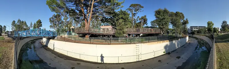
Adobe Creek crosses El Camino Real at Palo Alto's southern edge. The water district built the concrete channel between Alma Street and El Camino Real in 1959. The whole valley reach from El Camino Real to Highway 101 now runs in a trapezoidal channel. In Palo Alto the creek forms the southern edge of Charleston Meadows, where the Wilkie Way bridge crosses it, then passes Adobe Meadow and runs along the edge of Mitchell Park near the Magical Bridge Playground.
The Highway 101 bridge at Adobe Creek
For decades the only way across the freeway here was the Benjamin Lefkowitz Underpass beside the creek. The city says it was usable only about half the year on average because of seasonal flooding. The Highway 101 pedestrian and bike bridge at Adobe Creek replaced it. It opened with a ribbon cutting on November 20, 2021, crossing the freeway and East and West Bayshore Roads with a path 12 feet wide. The city lists the project cost at $23,734,218, including a $5.5 million grant from Santa Clara County's Stanford Recreation Mitigation Fund.
The Adobe Creek Reach Trail, built with the bridge, links East Meadow Drive with West Bayshore Road. Together they give south Palo Alto a year-round route to the shore. Our Bay Trail guide describes the ride from there.
The flood basin and the Adobe Creek Loop
Beyond the freeway the creek enters the Palo Alto Flood Basin, built after the floods of 1955 and held about 2 feet below sea level to absorb storm runoff. The levee trail around it is known as the Adobe Creek Loop Trail and forms part of the San Francisco Bay Trail network. Wikipedia describes it starting from the parking lot at the north end of San Antonio Road, just north of Highway 101:
- Head north on the levee with Adobe Creek on your left and Charleston Slough on your right.
- Follow the curve to the bay and west over the tide gate area at Mayfield Slough into the Baylands Nature Preserve.
- Return southwest with Matadero Creek on your left and Byxbee Park on your right to East Bayshore Road.
- Go east on the Bay Trail along East Bayshore Road, crossing Adobe Creek, back to the San Antonio Road lot.
We could not confirm a separately named Adobe Creek bridge on the Bay Trail beyond that East Bayshore crossing and the Highway 101 overcrossing. The loop is flat, exposed and good for birding, with American white pelicans often seen in winter.
Check closures first. Valley Water is retrofitting the 1957 tide gate, which sits half a mile northeast of the Byxbee Park parking lot on this loop. Its August 2025 fact sheet showed temporary closures of a 0.8-mile segment of the trail, including September 1 to October 15, 2026, with construction continuing into 2027.
Steelhead and native fish
Adobe Creek was once a trout stream. A Stanford professor collected a steelhead specimen in 1893 and a 1909 Los Altos brochure promoted a "never-failing mountain trout stream." The last record of a steelhead spawning above El Camino Real is a 27-inch fish caught by boys in June 1956 near Van Buren Street in Los Altos. The tide gate built at the creek's mouth in 1957 and the long concrete channel ending in a drop at El Camino Real now block the run. A 2011 survey still found native California roach, Sacramento sucker and three-spined stickleback above El Camino Real.
Visiting and safety
Good to know
- Getting there. From central Palo Alto, bike or drive to Mitchell Park on East Meadow Drive and follow the Adobe Creek Reach Trail to the 101 bridge. For the loop trail, drive Highway 101 to San Antonio Road and head north to the lot at its end.
- Dogs. Leashed dogs are allowed in the Palo Alto Baylands, on a leash no longer than 6 feet. Shoreline at Mountain View, just east of the loop, does not allow pets.
- Bikes. The bridge, the Reach Trail and the levee trails are open to bikes. Helmets are required in the Baylands and the speed limit is 15 mph.
- Stay out of the channel. The concrete reaches are flood control property and fill fast in storms.
- Ticks, poison oak and lions. In the upper canyon, Midpen warns that ticks may carry disease, poison oak grows on most preserves and mountain lions are occasionally seen. If you meet a lion, do not run.
Frequently asked questions
Where does Adobe Creek start?
It rises at about 2,600 feet on the northeast flank of Black Mountain in the Santa Cruz Mountains. Its upper watershed lies within Hidden Villa and Midpen open space. From there it flows about 14.2 miles north through Los Altos Hills, Los Altos and Palo Alto to the Palo Alto Flood Basin.
Is there a bridge over Highway 101 at Adobe Creek?
Yes. The City of Palo Alto's Highway 101 pedestrian and bike bridge at Adobe Creek opened on November 20, 2021. It crosses the freeway and East and West Bayshore Roads and replaced a seasonal underpass that flooded about half the year. The Adobe Creek Reach Trail links it to East Meadow Drive.
What is the Adobe Creek Loop Trail?
It is a levee loop around the Palo Alto Flood Basin that forms part of the San Francisco Bay Trail network. It runs north between Adobe Creek and Charleston Slough, crosses the tide gate area near the bay and returns along Matadero Creek past Byxbee Park. It is popular for birding, with American white pelicans in winter.
Did Adobe Systems get its name from Adobe Creek?
Yes. John Warnock and Charles Geschke both lived beside Adobe Creek in Los Altos and named their software company after it. The creek itself took its name from an adobe house built by Juan Prado Mesa, who received Rancho San Antonio in 1839.
Are there fish in Adobe Creek?
Steelhead once ran up the creek. The last record above El Camino Real is a 27-inch fish caught in June 1956. A 2011 survey found native California roach, Sacramento sucker and three-spined stickleback above El Camino Real. A tide gate and a long concrete channel now block steelhead runs.