On this page
At the southern tip of San Francisco Bay, past the office parks of North San Jose and the roar of Highway 237, the road drops into a village that looks nothing like Silicon Valley. Alviso has a few quiet streets of cottages and old wooden buildings and a branch library. Beyond the last houses lie miles of marsh and salt ponds. It is San Jose's only waterfront district.
For a Palo Alto visitor, Alviso is a short drive and a good add-on to a morning of birding or a bike ride on the levees. It is also one of the best places in the South Bay to see how the valley worked before the tech era, when grain, fruit and hides left by boat for San Francisco. This guide covers getting there, the port town history, a walk through the historic district, the floods and the new levee, the marsh, the library and why the trip is worth it. For park rules and paddling, see our separate Alviso Marina County Park guide.
Where Alviso is and how far
Alviso sits in the northern tip of San Jose on the southern shore of the bay. The Guadalupe River separates it from Santa Clara and Sunnyvale to the west. Coyote Creek separates it from Milpitas to the east. Highway 237 runs along its southern edge. Parts of the district lie below sea level.
From downtown Palo Alto it is about 13 miles. Outside rush hour the drive takes about 20 minutes.
Getting there from Palo Alto
By car
Take Highway 101 south, then Highway 237 east. Exit at North First Street and head north into Alviso. Street parking is easy in the village. The state's Water Trail program lists the county park lots as free.
By transit
Take Caltrain to Mountain View, then VTA light rail east along Tasman Drive to Baypointe station. From there, VTA bus route 59, which runs from Valley Medical Center to Baypointe via Alviso, finishes the trip. Allow more than an hour each way and check VTA's trip planner. Our Mountain View station guide covers the Caltrain to light rail transfer.
By bike
Levee trails in the Don Edwards refuge and the Bay Trail link Alviso with Sunnyvale's shoreline. Gaps, gates and seasonal closures change, so check the Bay Trail guide and the refuge's notices before you set out. If you need a bike, you can find a bike rental for the day.
From port town to San Jose district
The village is named for Ignacio Alviso, son of a soldier on the Anza expedition. In 1840 he moved from Mission Santa Clara to Rancho Rincón de los Esteros, about 3,653 acres at the edge of the bay. Hides, tallow and beaver pelts left from his landing for San Francisco.
Alviso incorporated on March 26, 1852 as the shipping port for San Jose and the valley. Steamboats ran regularly to San Francisco. The San Francisco and San Jose Railroad bypassed it in 1864. Trade drifted away, though a Southern Pacific line to Oakland later stopped here. Alviso Mills, founded in 1853, ground up to 300 barrels of flour a day until it closed in 1885.
In 1906 the Bayside Canning Company opened in Alviso. Under Thomas Foon Chew it grew into one of the largest canning companies in the country; our page on Thomas Foon Chew follows him to his later cannery in Palo Alto. During the Depression, Alviso was known for dance halls and gambling. In the 1960s and 1970s a small community of independent boat builders worked here.
The town's last census, in 1960, counted 1,174 people. In 1968 residents voted 189 to 180 to consolidate with San Jose. Alviso became part of the city on March 12, 1968. The Postal Service still recognizes Alviso as a place name. Residents pick up their mail at the post office.
Walking the historic district
On October 9, 1973, about 9 acres of the old town joined the National Register of Historic Places as the Alviso Historic District, with 11 historic structures listed under the alternate name Embarcadero de Santa Clara. Some have been lost since. A short walk takes in what remains:
- The Bayside Cannery building: a Mission Revival structure from 1906, the most striking building in town.
- The Tilden house: an Italianate Victorian on Elizabeth Street, built in 1887 by Susan Tilden and still a private home. View it from the street.
- The Laine Store site: the store at 996 Elizabeth Street ran from 1865 to 1912 and later became a gambling hall. Abandoned after the 1983 flood, it collapsed in 2017.
- The H. G. Wade Warehouse site: an 1860 grain and hay warehouse, a city landmark until it burned in June 2021.
Most buildings are private. Stay on public streets and be respectful of residents.
Floods and the new levee
Living below sea level on former marsh has always been risky. Severe floods hit Alviso repeatedly in the 20th century. In the early 1980s water stood as much as 10 feet deep in places, destroying homes and businesses. The town flooded again in 1995. Palo Alto residents who remember the 1998 San Francisquito Creek flood will recognize the story.
Relief is being built. Valley Water, the State Coastal Conservancy and the U.S. Army Corps of Engineers began Phase 1 of the South San Francisco Bay Shoreline Project in December 2021. It runs between Alviso Slough and the Guadalupe River on the west and Coyote Creek on the east. The first reach begins at Alviso Marina County Park. When complete, the levee is designed to protect north San Jose, including Alviso and the regional wastewater treatment plant, from a 100-year coastal storm and rising seas. Expect construction activity on some trails on weekdays.

The marsh and the refuge
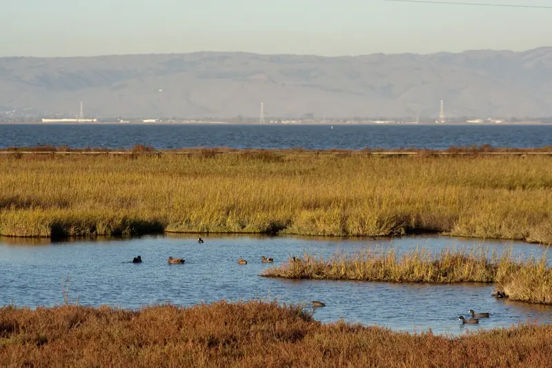
Beyond the houses lie the salt ponds and sloughs of the Don Edwards San Francisco Bay National Wildlife Refuge. Many ponds once produced salt and are being restored to tidal marsh. The refuge says more than 280 bird species use it each year. Millions of shorebirds and ducks stop here on spring and fall migrations. The endangered Ridgway's rail and salt marsh harvest mouse live in the marsh.
- Alviso Marina County Park: the village's old waterfront, with a boardwalk, levee trails, a boat launch and parking lots. See our park guide.
- Environmental Education Center: listed by the refuge at 1751 Grand Boulevard with no public hours posted. The nearby trails stay open sunrise to sunset.
- Day on the Bay: a free festival in the county park, usually on a Sunday in October.
Dogs are not allowed on the refuge's Alviso trails. Our Don Edwards refuge guide and birdwatching guide cover routes and seasons.
Library and village life
The Alviso Branch Library at 5050 North First Street is part of the San Jose Public Library system and a hub for the neighborhood. Hours vary by day, with afternoon openings on some days, so check the branch page. Alviso remains mostly residential, with only a few small businesses. Food choices are limited, so plan to bring a picnic for the county park or eat before you come.
Why a Palo Alto visitor might go
- Birds. Fall and winter bring huge flocks to the ponds, a short drive from Palo Alto.
- A different kind of history. A 19th century port, a cannery and a town that voted itself out of existence.
- Long, flat rides and walks. The levees go on for miles with almost no hills.
- Big sky. Views across the bay to Mount Hamilton and the Diablo Range are some of the widest in the valley.
Good to know
- Bring water, sun protection and a windbreaker; there is little shade.
- Mosquitoes can be heavy near the marsh in late summer.
- Levee work under the shoreline project can close sections on weekdays.
- There are no services on the levees, so plan breaks before you head out.
Frequently asked questions
Is Alviso part of San Jose?
Yes. Alviso incorporated as its own town on March 26, 1852 and stayed independent until residents voted 189 to 180 to consolidate with San Jose. The merger took effect on March 12, 1968. The Postal Service still recognizes Alviso as a place name.
Why does Alviso flood?
Parts of Alviso lie below sea level on former marshland at the edge of the bay, between the Guadalupe River and Coyote Creek. Floods in the early 1980s put up to 10 feet of water in some places. The town flooded again in 1995. A federal and local levee project now under construction aims to protect it from a 100-year coastal storm.
How do I get to Alviso from Palo Alto?
By car, take Highway 101 south to Highway 237 east and exit at North First Street, then head north into Alviso, about 20 minutes off-peak. By transit, ride Caltrain to Mountain View, take VTA light rail east to Baypointe and transfer to VTA bus 59, which runs via Alviso.
What is there to see in Alviso?
Walk the small historic district of 19th and early 20th century buildings, then head to Alviso Marina County Park for the boardwalk and levee trails into the Don Edwards refuge. Birders come for the shorebirds and ducks in the salt ponds, especially in fall and winter.
Is the Alviso Environmental Education Center open?
The U.S. Fish and Wildlife Service lists the center at 1751 Grand Boulevard but posts no public hours for it. The refuge trails beside it are open sunrise to sunset. Call the refuge before planning a visit around the building.