On this page
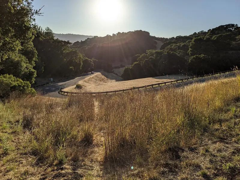
Turn off Arastradero Road onto Old Adobe Road and the city seems to fall away. Oaks arch over a narrow lane that climbs, dips and climbs again. Big houses sit far apart on lots of an acre or more. At the top, a hillside of open grass rolls toward the sky. This is the Esther Clark Park neighborhood, one of the most rural-feeling corners of Palo Alto.
It takes its name from the 21-acre preserve at its center and the doctor who gave it. It also holds the site of one of the most important houses in early California history. In 2026 it has been in the news for a fight over new housing. This guide covers all of it, plus schools, shops and getting around.
Where the neighborhood is
The neighborhood sits in southwest Palo Alto, just off Arastradero Road near its intersection with Foothill Expressway. Gunn High School is a short walk away. Palo Alto Online describes it as running from Old Adobe Road to Manuela Avenue, including Old Trace Road. Side streets include Mockingbird Lane, Robb Road and Oak Hill Avenue.
The setting is the lower edge of the foothills. Large corporate office buildings are just down the hill, while Los Altos Hills begins nearby. A planning commissioner said in 2026 that the neighborhood feels closer in character to Los Altos Hills than to the rest of Palo Alto. Greater Miranda is a short distance east across Foothill Expressway. Palo Alto Hills lies higher up, west of Interstate 280.
History: a rancho and a doctor's gift
Juana Briones de Miranda
This hillside was once part of Rancho La Purisima Concepcion, about 4,400 acres that Juana Briones de Miranda bought in 1844 from two Native Californian men from Mission Santa Clara. Briones was a healer, rancher and businesswoman. She was also one of the few women who held a rancho in her own name. She lived in an adobe home on the property for many years.
That house stood at 4155 Old Adobe Road. It survived into the twenty-first century but was demolished in June 2011 after a long legal battle between the owners and preservationists. The site is California Historical Landmark No. 524. The state plaque stands near the corner of Old Adobe Road and Old Trace Lane. Our page on the Spanish and Mexican era tells more of her story.
Dr. Esther Clark
In the twentieth century much of this land belonged to Dr. Esther Clark, a founding member of the Palo Alto Medical Clinic who also founded the Children's Health Council. A neighbor told Palo Alto Online that Clark owned the property, developed Old Adobe Road and arranged for the hillside to stay open space. She sold that land to the city on that condition. It became Esther Clark Park.
One original owner told the Weekly she bought her lot directly from Clark and moved into her house on Old Adobe Road when it was finished in 1974. She remembered the hills across from her as so empty that neighbors hit golf balls into them.
Housing in general terms
Many blocks here carry Palo Alto's rare residential estate zoning, which calls for very large lots. Palo Alto Online described lots of at least an acre. The houses include:
- older ranch homes on wide, wooded lots
- large Spanish style villas with stucco and tile roofs
- newer, bigger houses that have replaced smaller rustic originals
Longtime residents have noted the shift from small, spread-out houses to larger ones. The lanes are narrow and many lack sidewalks. Wildlife is part of daily life, with deer, jackrabbits and ground squirrels common between homes. The neighborhood sits at the edge of the foothills, where city leaders acknowledged higher fire risk in 2026, so buyers should check fire hazard maps and insurance options early. Our guide to emergency preparedness covers evacuation planning. See our real estate guide for the wider market.
The 4103 Old Trace Road project
In 2026 the neighborhood became the center of a citywide debate about state housing law. A developer, Steel Bridge Property, proposed a project at 4103 Old Trace Road near the corner of Arastradero Road. The first version had nine homes plus seven accessory and junior accessory units, 16 units in all.
Residents objected strongly. They argued that more cars on Old Trace Road and Mockingbird Lane would block fire evacuation and emergency access. Palo Alto Online reported that the Planning and Transportation Commission voted unanimously on April 29, 2026 to advance the project while sharing many of the neighbors' concerns. The City Council approved a tentative map in May, saying state law left little room to refuse.
In June 2026 the developer filed a revised application for 13 townhomes, one with an accessory unit and another with an accessory unit plus a junior unit, still 16 units total. The developer says the plans add a second exit to Arastradero Road and new sidewalks. Projects like this can change again before construction, so check the City of Palo Alto planning pages for the current status.

Parks and open space
Esther Clark Park is the heart of the neighborhood. It covers about 21 acres of grassland and oaks with informal paths and no facilities. Residents walk, jog and ride horses there. There is no parking lot, so visitors should walk or bike in and keep the narrow lanes clear.
More open space is close. Pearson-Arastradero Preserve is a short ride up Arastradero Road, with longer trails through grassland and oak woodland. Higher up Page Mill Road, Foothills Nature Preserve adds lakes and ridge views. A bike is a good way to link them; rent one if you are visiting.
Schools by attendance area
Palo Alto Online listed these public schools for the neighborhood:
- Nixon Elementary at 1711 Stanford Avenue, on Stanford land.
- Terman Middle School, renamed Ellen Fletcher Middle School in 2018, at 655 Arastradero Road.
- Gunn High School at 780 Arastradero Road.
The elementary assignment surprises some newcomers, since Nixon is about a mile and a half north near Stanford. Boundaries can change, so confirm any address with the PAUSD school finder.
Shopping and getting around
There are no shops here. Residents told the Weekly they are about five minutes from Los Altos and close to downtown Palo Alto and Stanford. Everyday errands happen along El Camino Real, in downtown Los Altos and at the San Antonio shopping area in Mountain View.
This is car country. Foothill Expressway and Page Mill Road lead to Interstate 280 and Stanford Research Park. Arastradero Road leads east to El Camino Real. Public transit is thin. Council members and commissioners noted the lack of good transit near Gunn during the 2026 housing debate. Arastradero Road is busy at school times.
Community and neighborhood groups
The neighborhood is small and informal. Residents have described barbecues at the end of the street that bring longtime and new neighbors together. In 2026 a group of residents organized to speak at city hearings on the Old Trace Road project. Palo Alto Online's profiles do not name a formal neighborhood association. Check the City of Palo Alto's neighborhood association list for any current contact.
Good to know
- Roads are narrow with few sidewalks. Drive slowly and park only where it is clearly allowed.
- Check wildfire hazard maps and insurance before you buy.
- Fire Station No. 5 at 600 Arastradero Road serves the area.
Visitors coming to explore the preserves can stay on El Camino Real, a short drive east. Compare hotels on El Camino Real before you book.
Frequently asked questions
Where is the Esther Clark Park neighborhood?
It is in southwest Palo Alto off Arastradero Road, near the intersection with Foothill Expressway and a short walk from Gunn High School. Palo Alto Online describes it as running from Old Adobe Road to Manuela Avenue and including Old Trace Road.
Who was Esther Clark?
Dr. Esther Clark was a founding member of the Palo Alto Medical Clinic and founded the Children's Health Council. She owned much of this land, developed Old Adobe Road and sold the hillside that became Esther Clark Park to the city on the condition that it stay open space.
What was the Juana Briones house?
It was the home of Juana Briones de Miranda on her Rancho La Purisima Concepcion, at 4155 Old Adobe Road. After a long legal fight with preservationists it was demolished in June 2011. The site is California Historical Landmark No. 524, with a plaque near Old Adobe Road and Old Trace Lane.
What is happening at 4103 Old Trace Road?
A developer proposed 16 housing units there in 2026, later revised to 13 townhomes plus three accessory units. Neighbors objected over fire evacuation and parking. The City Council approved a tentative map in May 2026 and said state housing law left little room to refuse. Check the city's planning pages for the current status.
Which schools serve the Esther Clark Park neighborhood?
Palo Alto Online listed Nixon Elementary, Terman Middle School (now Ellen Fletcher Middle School) and Gunn High School. Confirm any address with the Palo Alto Unified School District school finder, since boundaries can change.