On this page
Evergreen Park is the residential pocket wrapped around the back of the California Avenue business district. It began as part of Mayfield, the farm town that grew up on El Camino Real decades before Palo Alto existed. Land here was sold under the Evergreen Park name from 1907 and filled with cottages and bungalows in the 1920s. Mayfield joined Palo Alto in 1925. The old names faded until residents revived Evergreen Park for their neighborhood association in 1980.
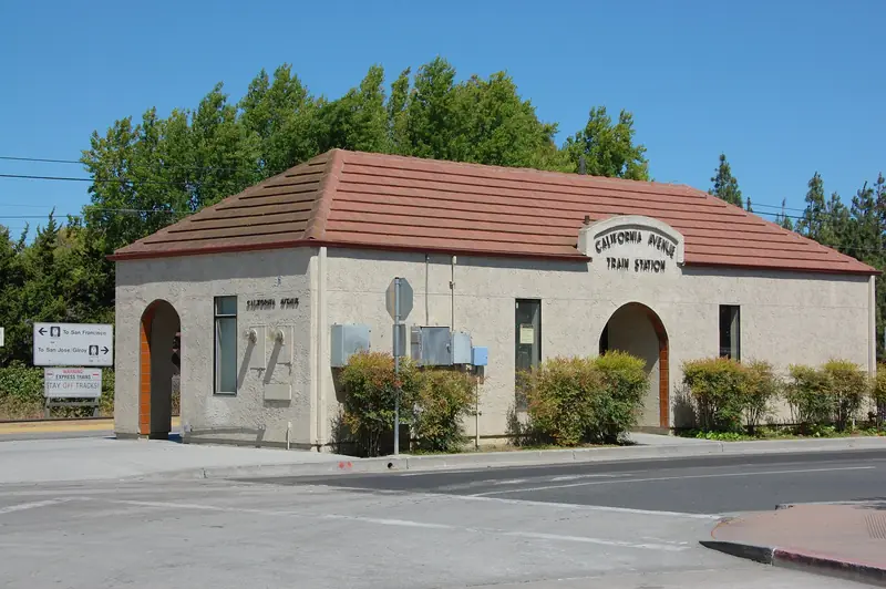
This loop starts and ends at the California Avenue station. It takes in the neighborhood's park, a few houses on the city's Historic Inventory, the marker for Mayfield's first building and a stretch of the car-free avenue. For boundaries, schools and the parking program, read our Evergreen Park neighborhood guide.
Before you go
The loop is about 1.8 miles and takes about an hour at an easy pace. Both figures are our estimates. Add time if you stop at the dog run or for lunch. The route is flat and mostly shaded on the residential streets.
- By train: California Avenue station is one stop south of downtown Palo Alto on Caltrain. Our Caltrain guide has schedules.
- By car: Evergreen Park has a residential permit program and many blocks have time limits. The public garage at 350 Sherman Avenue, south of California Avenue, is the simpler choice.
- Sunday mornings: The farmers market fills the avenue and nearby parking. It is a lively time to finish the walk but a hard time to park.
The route, stop by stop
- California Avenue Caltrain station. Start on the avenue side. If you have ten minutes, take the pedestrian underpass to Bowden Park on the other side of the tracks, a 1960 modernist garden by Robert Royston with Marta Thoma's running figures, Rrrun. Then come back and head north on Park Boulevard.
- 2110 Park Boulevard. The first house of note is rated Category 2 on the city's Historic Inventory, a "Major Building" of regional importance. It is a private home. Notice how close the houses on this stretch sit to the sidewalk compared with later tracts.
- Peers Park, 1899 Park Boulevard. The neighborhood park covers 4.7 acres with two play structures, tennis and basketball courts, a lawn and a small field house the city rents for parties. Its namesake, Alexander Peers, lived in Mayfield for 59 years. With William Page he ran the Page and Peers Lumber Company, which hauled foothill timber down a road that still carries Page's name: Page Mill Road. Peers sat on Mayfield's first Board of Trustees and was the first president of the Mayfield Bank.
- The Challenger Memorial Grove. Walk behind the tennis courts. These redwoods grew from seeds of El Palo Alto, the city's namesake tree. The city says the seeds orbited Earth in 1985 aboard the Space Shuttle Challenger on mission STS-51F. A plaque names the grove for the shuttle and its crew, lost in January 1986. Our El Palo Alto page covers the parent tree.
- The Peers Park dog run. On the way out, look at the fenced off-leash area. It opened in 2018 and covers 0.84 acre, which the city lists as the largest of its four dog parks. It has a separate small dog area and keeps its own hours, 7 a.m. to 9 p.m. Our Peers Park guide covers the rules.
- 1795 Park Boulevard. Continue north a short way. This house is a Category 3 contributor on the inventory. Beyond it the streets begin to blend into Southgate, the 1920s tract covered in our Southgate walking tour.
- Leland and Stanford avenues. Turn west toward El Camino Real. The city lists 390 Leland Avenue and 352 and 374 Stanford Avenue in Category 4. Look for the small cottages and bungalows with detached garages at the back, the original 1920s pattern here, between the newer two-story rebuilds.
- El Camino Real. At the end of the block the old county road runs along the neighborhood's western edge. Across it is Stanford land. Turn south and walk toward California Avenue. This was Mayfield's main street, the road that brought travelers to its roadhouses and saloons.
- Uncle Jim's Cabin marker, 2401 El Camino Real. On the California Avenue side of this building, a 1969 city marker says James Otterson opened a hostelry near this corner in 1853. It was the first building in what became Mayfield. Town lots followed in 1867. Mayfield banned saloons in 1904 and the ban took effect in January 1905. Our Mayfield history tells the rest.
- California Avenue's car-free blocks. Walk east along the avenue toward the station. The blocks from El Camino Real to Birch Street have been permanently closed to cars since a council vote on March 10, 2025. Near 440 California Avenue, at Mimosa Lane, look for Sunflowers, a 2003 stainless steel sculpture by Jennifer Madden and Jeffrey Reed in the city's public art collection. Then finish with coffee at 344 California Avenue and walk the last few blocks back to the station.

Coffee and snacks
ZombieRunner, at 344 California Avenue, is a coffee shop run by a company that also sells running gear. Our business directory recorded hours of 8 a.m. to 4 p.m. Monday to Saturday when it checked the shop on October 29, 2026. Sunday hours vary, so check its website. If you set out from the north end instead, Starbucks at 2000 El Camino Real sits on the neighborhood's edge. Our guide to California Avenue lists the restaurants on the car-free blocks.
What to look for
Evergreen Park is not a historic district and most of its houses are not individually listed. What makes it interesting is the layering. A short walk shows:
- 1920s bungalows and cottages on narrow lots, often with the garage tucked at the back of the lot.
- Rebuilds of two stories where a cottage once stood. Palo Alto Weekly has described the neighborhood as steadily moving upscale.
- Apartments and condominiums near Park Boulevard and the edges of the business district. A Weekly count put the area at about 206 single-family homes and 178 multifamily units.
- Mature street trees on a regular grid, which shade the residential blocks on warm afternoons.
The inventory numbers used above come from the City of Palo Alto's Historic Inventory list. Category 2 marks a "Major Building." Categories 3 and 4 mark "Contributing Buildings" that are good local examples of their style.
Accessibility notes
- The route is flat. Sidewalks on the residential blocks are continuous but narrow in spots, with some root damage.
- Peers Park is the only stop with restrooms on the city's list. It also has benches and shade.
- The car-free blocks of California Avenue offer a wide, smooth surface. Tables and planters take up part of the roadway at mealtimes.
- Cross El Camino Real and Park Boulevard only at signals or marked crosswalks.
- Skip the Bowden Park detour if stairs or ramps at the station underpass are a problem. Check conditions on site before you commit.
Sidewalk etiquette
Good to know
- The houses named on this page are private homes. View them from the public sidewalk and do not step onto lawns or driveways.
- Do not photograph residents or into windows.
- Keep dogs leashed outside the fenced run at Peers Park and pick up after them.
- Evergreen Park streets fill with parked cars on weekdays. Walk facing traffic where there is no sidewalk.
Making a day of it
Evergreen Park pairs well with our California Avenue walking tour, which covers the Mayfield depot area, the courthouse and the old cannery south of the avenue. The two together make a half day of about 3.5 miles. For a longer outing, cross El Camino Real at California Avenue and continue into College Terrace.
Sources
Inventory categories come from the City of Palo Alto's Historic Inventory list. Peers Park details follow the city's park, field house and dog park pages. Marker text comes from the Historical Marker Database and our history pages. The sculpture listing comes from the city's public art collection. Distances are our estimates.
Frequently asked questions
What is the Challenger Memorial Grove at Peers Park?
It is a group of redwoods behind the tennis courts at Peers Park. According to the city, they grew from seeds of El Palo Alto that flew aboard the Space Shuttle Challenger in 1985 on mission STS-51F. A plaque names the grove for the shuttle and crew lost in January 1986.
How long is the Evergreen Park walking tour?
By our estimate the loop is about 1.8 miles and takes about an hour. It starts and ends at the California Avenue Caltrain station, so it works well as a car-free outing.
Where does Mayfield's history show up on this walk?
Evergreen Park was part of the town of Mayfield, which Palo Alto absorbed in 1925. A 1969 city marker for Uncle Jim's Cabin, an 1853 roadhouse, stands on the California Avenue side of 2401 El Camino Real. Peers Park is named for one of Mayfield's leading citizens.
Can I bring my dog on this walk?
Yes, on a leash. Peers Park has the city's largest fenced dog run, 0.84 acre, open 7 a.m. to 9 p.m. Dogs must stay leashed everywhere else in the park and on the streets.
Where can I get coffee near Evergreen Park?
ZombieRunner at 344 California Avenue is near the end of the loop. Our directory recorded hours of 8 a.m. to 4 p.m. Monday to Saturday in late October 2026. California Avenue has several other cafes and the Sunday farmers market.