On this page
Southgate is one of the smallest named neighborhoods in Palo Alto, a few blocks of houses between El Camino Real and the railroad just south of Churchill Avenue. It was laid out from 1923 for families who owned cars, which set it apart from the older blocks near the University Avenue station. A century later it still has narrow streets, stucco houses and the 1920s street light fixtures the city has asked owners and crews to keep.
This route reaches Southgate the way many residents do, past the shopping center and the high school on its northern edge. Our Southgate neighborhood guide covers boundaries, schools and the parking program.
Before you go
The walk runs about 2 miles one way and takes about an hour. Both figures are our estimates. It starts at Town & Country Village at Embarcadero Road and El Camino Real and ends at Peers Park on Park Boulevard, a short walk from the California Avenue Caltrain station. Our Caltrain guide covers the ride home.
- Getting there: Town & Country has a large surface lot. VTA buses on El Camino Real stop nearby.
- School hours: Churchill Avenue and the Paly frontage are busy at the start and end of the school day. Mid-morning, weekends and summer are calmer.
- Light: The period street lights are the reason to walk Southgate late in the day. A dusk walk shows them working.
Coffee at the start
Manresa Bread runs one of its five cafes in Town & Country Village, at 855 El Camino Real. It pours coffee to go with its breads and pastries. Boichik Bagels and a Peet's are in the same center. Once you leave Town & Country there are no shops on the route, so buy water here. Our guide to eating near Town & Country lists everything in the center.
The route, stop by stop
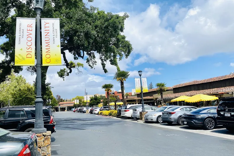
- Town & Country Village, 855 El Camino Real. This open-air center opened in 1953, two years before Stanford Shopping Center's first store. Palo Alto resident Ronald Williams developed it on a 14-acre parcel known as the Greer property and kept dozens of mature oaks. Walk the paths between the low buildings and look up at the trees before you leave.
- Palo Alto High School, 50 Embarcadero Road. Cross Embarcadero at the signal. Paly has been on this corner since December 1918. On December 24 of that year staff, students and the school board marched here from the old high school at Channing Avenue and Webster Street. The city's Historic Inventory rates the campus address Category 2. The Tower Building, whose hallway generations of students have walked, now also houses the Palo Alto Adult School. Stay on the public sidewalk.
- El Camino Real frontage. Walk south along the campus edge. Across the road is Stanford land. Walter Hays, president of the school board, is credited with bringing Palo Alto, Stanford and the town of Mayfield together on this site when a deal seemed unlikely.
- Churchill Avenue. Turn left onto Churchill, the northern edge of Southgate. The inventory lists 305 and 460 Churchill in Category 2 and 236, 263 and 369 Churchill in Category 4. At the far end, the street-level rail crossing is one the city has studied for years in its grade separation planning. Any change there will shape how Southgate reaches the rest of town.
- Castilleja and Miramonte avenues. Turn south into the tract. The city lists 1621 Castilleja Avenue and 220 and 260 Miramonte Avenue in Category 4, the inventory's "Contributing Building" tier. Notice how the stucco period revival houses sit beside later ranch houses and rebuilds.
- The 1920s street lights. As you walk the interior streets, watch for the old lamp standards. The city's survey update said these 1920s fixtures "have aesthetic value and should be maintained." They are the most consistent original feature left in the neighborhood.
- The Spanish street names. Loop through Madrono, Manzanita, Sequoia, Escobita, Mariposa and Portola avenues. Madrone, manzanita and sequoia are California trees and shrubs. Mariposa is Spanish for butterfly. The streets are narrow, which is why parking became such a long fight with Paly next door.
- Park Boulevard. Leave the tract on its southeast edge and walk south on Park Boulevard. The tracks are just beyond the houses on your left. Southgate has few entrances, which is why so little through traffic reaches its interior streets.
- Peers Park, 1899 Park Boulevard. Finish in Evergreen Park's 4.7-acre park, which Southgate residents use as their own. It has restrooms, benches, playgrounds and a grove of redwoods grown from seeds of El Palo Alto that flew on the Space Shuttle Challenger in 1985. Our Evergreen Park walking tour starts from here in reverse.

How Southgate was planned
Before the houses, this was orchard land. Palo Alto Weekly has reported that it belonged to the Stanford family, which sold it for development in the 1920s. The name refers to its place on the south side of the Stanford lands. The Palo Alto Development Company designed the subdivision and building ran from 1923 into the 1950s.
The early rules were typical of the era. The 1923 land documents banned alcohol and poultry, according to the Weekly. A 1924 newspaper advertisement called the first phase Palo Alto's finest residential section, with lots from $660. The city's historic survey describes the result as an upper middle class neighborhood developed for automobile owners, with stucco houses in period revival, ranch and modern styles.
That same survey looked at Southgate as a possible historic district and decided the case was not documented well enough. Many houses had been altered and the criteria for contributors had not been defined. So Southgate has no district status, unlike Professorville. A handful of houses are on the inventory on their own merits. Our historic homes guide explains how that works.
What to look for
- Stucco walls in light colors, the survey's defining material for the tract.
- Period revival details such as arched windows and tile roofs on some of the oldest houses.
- Ranch houses from the years around World War II, built as the last lots filled.
- Rebuilds of two stories. Remodeling has been close to constant here for years.
- Driveways and garages, a reminder that the survey calls this a tract developed for automobile owners.
Our Spanish Colonial Revival guide shows where the same style appears in grander form around town.
Accessibility notes
- The route is flat. Sidewalks along El Camino Real and Embarcadero Road are wide.
- Inside Southgate the streets are narrow and parked cars crowd the curb. Some sidewalks are narrow or broken by roots.
- Cross Embarcadero Road and El Camino Real only at signals. Both carry heavy traffic.
- Restrooms: Town & Country's businesses at the start and Peers Park at the finish. Nothing in between.
Sidewalk etiquette
Good to know
- Every Southgate house is a private home. Stay on the sidewalk or street edge and never enter yards or driveways.
- Paly is a school. Do not enter the campus during school hours and do not photograph students.
- Keep voices low on the narrow interior streets, where sound carries.
- Many blocks have permit parking. Read signs if you drive to the start.
Sources
Tract history follows the City of Palo Alto's summary of its 1997 to 2001 historic survey update and Palo Alto Weekly reporting. Street names come from the city's Southgate parking permit map. Inventory categories come from the city's Historic Inventory list. School history follows Paly's own history page. Distances are our estimates.
Frequently asked questions
Is Southgate a historic district?
No. The city's 1997 to 2001 historic survey update looked at Southgate and found it was not documented well enough to treat as a district, partly because of later alterations. The same survey said the 1920s street light fixtures have aesthetic value and should be kept.
How long does the Southgate walk take?
By our estimate the route is about 2 miles from Town & Country Village to Peers Park and takes about an hour. The California Avenue Caltrain station is about a third of a mile from the finish.
Can I walk through the Palo Alto High School campus?
Paly is a working school. During school hours visitors should stay on the public sidewalks along El Camino Real, Embarcadero Road and Churchill Avenue. The Tower Building and the campus front are easy to see from there.
Where can I get coffee on the Southgate walk?
Start at Manresa Bread in Town & Country Village, 855 El Camino Real. The center has several other cafes and a Trader Joe's. There are no shops inside Southgate itself.