On this page
California Avenue is the Palo Alto main street that locals often prefer to the more famous one. It has restaurants, cafes and small shops along a few walkable blocks. It has its own Caltrain station at one end and El Camino Real at the other. Since 2020 the central stretch has been closed to cars, so tables, planters and bikes fill the roadway where traffic once ran.
The street also has a longer story than most of Palo Alto. It was the main street of Mayfield, a town that existed before Stanford University or Palo Alto did. This guide covers that history, the train station, the Sunday market, the car-free changes and the neighborhood around it.
Mayfield's main street
Mayfield grew up in the 1850s near a stagecoach stop and saloon called Uncle Jim's Cabin, close to where El Camino Real meets today's California Avenue. The name came from Mayfield Farm, a property to the south that later became the Barron Park neighborhood. Regular trains reached Mayfield in October 1863. A storekeeper donated land on the main street, then called Lincoln, for the station.
By the 1880s Mayfield had stores, hotels, a blacksmith, a newspaper and a brewery. The Mayfield Brewery opened in 1868 at what is now the corner of California Avenue and Birch Street. The town also had more saloons than its size would suggest. Local historians count 13 of them.
Those saloons shaped the region. Leland Stanford wanted a dry town at the gates of his new university and Mayfield refused to close its bars. Stanford's allies backed a new townsite to the north instead, which became Palo Alto. Mayfield eventually banned saloons in the early 1900s, but by then the growth had moved north. Our history of Palo Alto tells that story in full.
Mayfield incorporated in 1903. It never thrived on its own. Palo Alto voters approved annexation on July 2, 1925. The two towns were formally consolidated on July 6, 1925. Because Palo Alto already had a Lincoln Avenue, Mayfield's main street was renamed California Avenue. The merger left Palo Alto with two downtowns, a fact the city still plans around today.
The California Avenue Caltrain station
The station at 101 California Avenue sits where the street meets the tracks. It was called Mayfield until 1941, when it took the street's name. The first station building went up in 1869. It was replaced in 1955 and again in 1983.
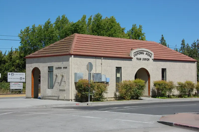

In 2008 the station was rebuilt with two side platforms and a pedestrian underpass, replacing a single center platform that only one train could use at a time. The underpass also links California Avenue with the residential streets east of the tracks, so it is the quickest walking route between the shops and neighborhoods such as Old Palo Alto and Midtown.
Local and limited trains stop here. Express trains skip it. Caltrain switched to electric trains in 2024, so service is quieter than it used to be. Always check the Caltrain website for the current timetable and fares. For other options, see our getting around guide and our page on getting to Palo Alto.
The car-free street
In June 2020, early in the pandemic, the city closed California Avenue to through traffic between El Camino Real and Birch Street so restaurants could serve outside. It was meant to be temporary. Diners and many merchants liked it, though some business owners argued for reopening.
The debate took several years. Here is how it unfolded:
- June 2020: The street closes to cars as an emergency recovery measure.
- November 6, 2023: The City Council directs staff to keep California Avenue car-free and make the closure permanent.
- March 10, 2025: The council votes unanimously to make the closure permanent and creates a new "community street" classification. Bikes are allowed, with an 8 mph speed limit approved by the council. City surveys found about 79 percent of respondents supported keeping it car-free.
- Spring 2025: Orange plastic barriers give way to bollards, colored asphalt and planters at the El Camino Real, Ash Street and Birch Street entrances.
- April 2026: The Architectural Review Board recommends standards for outdoor activation and pre-approved parklet designs that restaurants can use, sending them on to the council.
Longer-term design work on signage, outdoor dining rules and the look of the street is still underway with a city consultant. Details may have changed since this guide was updated, so check the City of Palo Alto car-free streets page for the latest. Cross streets such as Ash and Birch still carry traffic, so watch for cars at each intersection.
The Sunday farmers market
Every Sunday from 9 a.m. to 1 p.m. the California Avenue Farmers Market fills the street near El Camino Real. It runs year-round in rain or shine. The Urban Village Farmers' Market Association operates it. Expect California produce, flowers, baked goods, eggs, cheese and prepared food.
- EBT, WIC and a matching program are accepted. EBT shoppers get a dollar for dollar match up to $15 to spend on fruits and vegetables.
- A knife sharpening service sets up on the first Sunday of each month.
- The market closes on some holiday weekends. The market's page posts the schedule.
Arrive before 10 a.m. for the best selection and easier parking. Many locals ride bikes and lock up at the racks near the street's entrances. The market pairs well with a late breakfast at one of the cafes and a walk into the residential blocks nearby.
Eating and drinking
Dining is the main reason people come. With the roadway closed, most restaurants have tables outside under umbrellas or in parklets. The mix runs from coffee and bakeries to sit-down dinners.
Two long-running examples show the range. La Bodeguita del Medio is a Cuban restaurant and rum bar on the avenue. Terún serves Neapolitan pizza and Italian dishes. Many other spots change over the years, so use our food and drink guide and our page on coffee in Palo Alto for current picks. Weekday lunch is busy with office workers. Weekend evenings draw families and couples from across the south side of town.
The neighborhood around it
The business district is small. Within a few blocks the shops give way to houses and apartments. The residential area closest to the avenue is Evergreen Park, which mixes older single-family houses with newer apartment and condo buildings. Southgate lies to the northwest. College Terrace sits just across El Camino Real.
A few civic buildings anchor the area. The Palo Alto Courthouse of the Santa Clara County Superior Court is at 270 Grant Avenue, a short walk from the car-free blocks. Jerry Bowden Park, a small city park, sits beside the tracks near the station. Offices along the side streets keep the area busy on weekdays.
Good to know
- Bikes share the car-free blocks with people walking and dining. Ride slowly. The council set an 8 mph limit.
- Public parking is in nearby lots and garages, plus paid spaces at the Caltrain station. Read posted time limits carefully.
- The farmers market makes Sunday mornings the busiest time of the week.
- The station underpass is the easiest way to cross the tracks on foot.
How to spend a few hours here
Take Caltrain to California Avenue or bike in on one of the quiet side streets. On a Sunday, start at the farmers market. On other days, start with coffee and walk the car-free blocks from the station toward El Camino Real. Look for the corner of California Avenue and Birch Street, once home to the Mayfield Brewery. Then cross El Camino Real to wander the college-named streets of College Terrace, or head south toward the semi-rural lanes of Barron Park.
California Avenue has no large hotels of its own. Most visitors stay downtown or along El Camino Real and come here by train, bike or a short drive. You can compare hotels near California Avenue or see our where to stay guide. For a broader view of how this part of town fits with the rest of the city, visit the neighborhoods overview.
Frequently asked questions
Is California Avenue in Palo Alto closed to cars?
Yes. The stretch from El Camino Real to Birch Street has been closed to through traffic since June 2020. In March 2025 the City Council made the closure permanent and classified it as a community street where bikes are allowed at low speed. Cross streets remain open to cars.
When is the California Avenue farmers market?
It runs every Sunday from 9 a.m. to 1 p.m., year-round and rain or shine. The Urban Village Farmers' Market Association operates it on California Avenue near El Camino Real. Check the association's closure schedule before holiday weekends.
Why is California Avenue called Palo Alto's second downtown?
It was the main street of Mayfield, an older town that Palo Alto annexed in 1925. After the merger the city had two commercial centers, University Avenue and California Avenue. The street was renamed at that time because Palo Alto already had a Lincoln Avenue.
Do express trains stop at California Avenue station?
Local and limited Caltrain trains stop at California Avenue. Express trains do not. Check the current Caltrain timetable since stopping patterns change from time to time.
Where do you park for California Avenue?
Because the main block is car-free, visitors park on side streets or in nearby public lots and garages and walk in. The California Avenue Caltrain station also has paid parking. On Sunday mornings during the market, parking fills early, so many locals bike.